La app de movilidad urbana más popular en Manhattan.
Todas las opciones de movilidad local en una aplicación
Las siguientes líneas de transporte tienen rutas que pasan cerca de Marble Hill 225th Street Station
Pulsa en la ruta de autobús para ver indicaciones paso a paso con mapas, tiempos de llegada de línea y horarios actualizados.
Pulsa en la ruta de tren para ver indicaciones paso a paso con mapas, tiempos de llegada de línea y horarios actualizados.
Pulsa en la ruta de metro para ver indicaciones paso a paso con mapas, tiempos de llegada de línea y horarios actualizados.
Las paradas más cercanas a Marble Hill 225th Street Station son:
Estas líneas de autobús se detienen cerca de Marble Hill 225th Street Station: BX7, BXM1, BXM2.
HUDSON
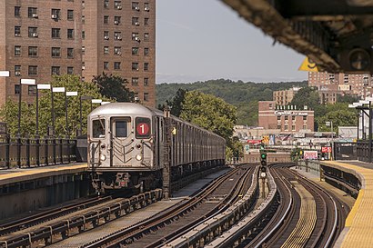
1
La estación más cercana de metro a Marble Hill 225th Street Station en Manhattan es Marble Hill-225 St. Está a 3 min a pie.
La estación más cercana de tren a Marble Hill 225th Street Station en Manhattan es Marble Hill. Está a 5 min a pie.
La parada más cercana de autobús a Marble Hill 225th Street Station en Manhattan es W 225 St/Broadway. Está a 2 min a pie.
El 1 es el primer metro que para cerca de Marble Hill 225th Street Station en Manhattan a las 3:02.
El A es el último metro que para cerca de Marble Hill 225th Street Station en Manhattan a las 4:30.
El HUDSON es el primer tren que para cerca de Marble Hill 225th Street Station en Manhattan a las 5:24.
El HUDSON es el último tren que para cerca de Marble Hill 225th Street Station en Manhattan a las 2:13.
El BX9 es el primer autobús que para cerca de Marble Hill 225th Street Station en Manhattan a las 3:30.
El BX9 es el último autobús que para cerca de Marble Hill 225th Street Station en Manhattan a las 2:59.
La tarifa del viaje en autobús hasta Marble Hill 225th Street Station cuesta aproximadamente $7.00.
La tarifa del viaje en metro hasta Marble Hill 225th Street Station cuesta aproximadamente $2.90.
La tarifa del viaje en tren hasta Marble Hill 225th Street Station cuesta aproximadamente $3.25 - $15.25.
¿Te preguntas cómo llegar a Marble Hill 225th Street Station en Manhattan, Estados Unidos? Moovit te ayuda a encontrar la mejor manera de llegar a Marble Hill 225th Street Station con indicaciones paso a paso desde la estación de transporte público más cercana.
Moovit proporciona mapas gratuitos y direcciones en vivo para ayudarte a navegar por tu ciudad. Mira los horarios, las rutas, los servicios y descubre cuánto tiempo lleva llegar a Marble Hill 225th Street Station en tiempo real.
¿Buscas la estación o parada más cercana a Marble Hill 225th Street Station? Mira esta lista de paradas más cercanas a tu destino: W 225 St/Broadway; Marble Hill-225 St; Broadway/W 225 St; Marble Hill; Broadway/W 220 St; W 230 St/Broadway; Broadway/W 219 St; Inwood-207 St.
Autobús:Tren:Metro:
¿Quieres ver si hay otra ruta que te lleve allí antes? Moovit te ayuda a encontrar rutas y horarios alternativos. Obtén fácilmente instrucciones y direcciones desde Marble Hill 225th Street Station con la aplicación Moovit o desde el sitio web.
Hacemos que viajar a Marble Hill 225th Street Station sea fácil, por eso más de 1.5 millones de usuarios, incluidos los usuarios de Manhattan, confían en Moovit como la mejor aplicación de transporte público. No necesitas descargar una aplicación de autobús individual o una aplicación de tren, Moovit es tu aplicación de transporte todo en uno, que te ayuda a encontrar el mejor horario de autobús o de tren disponible.
Para información de precios de metro, autobús y tren, costos y tarifas de viaje a Marble Hill 225th Street Station, por favor, revisa la aplicación Moovit.
Usa la aplicación para navegar a lugares populares, como el aeropuerto, hospital, estadio, tienda de alimentos, centro comercial, cafetería, escuela, facultad y universidad.
Ubicación: Manhattan, New York - New Jersey
Viajar por Manhattan nunca ha sido tan fácil. Obtén indicaciones paso a paso mientras viajas a cualquier destino, calle o parada. Mira los horarios de trenes y autobuses, alertas de servicio y detalles de las rutas en el mapa, para que sepas exactamente cómo llegar a cualquier parte de Manhattan.
Cuando viajas a cualquier destino de Manhattan usa la herramienta ¡Vamos! con alertas para saber cuando bajar, dónde y cuánto caminar, cuánto tiempo esperar a tu línea y cuántas paradas quedan. Moovit te avisará cuando llegue el momento de bajar - no es necesario fijarse de nuevo si la parada siguiente es la tuya.
¿Te has preguntado cómo utilizar el transporte público en Manhattan o cómo pagar el transporte público en Manhattan? La aplicación de Moovit puede ayudarte a viajar en transporte público fácilmente. Incluye las tarifas de tu viaje completo en transporte público, los precios de los tickets y costos adicionales. ¿Buscas un mapa de las líneas de transporte público de Manhattan? La aplicación de Moovit muestra todos los mapas de transporte público en Manhattan con todas las rutas y paradas de metro, autobús o tren en un mapa interactivo.
Manhattan tiene 3 tipos de transporte, incluyendo: metro, autobús o tren, operado por agencias de transporte público, incluyendo MTA Subway, Metro-North Railroad, LIRR, PATH, Shore Line East, MTA Bus Company, MTA New York City Transit - Express routes, MTA Bus, NJ Transit, NYC Ferry, NICE bus, Bee-Line Bus, NJ Transit Rail, NJ Transit Rail y Norwalk Transit District