Rookery St stop - Wednesday schedule
| Line | Direction | Time |
|---|---|---|
| 9 | Walsall Bus Station | 06:24 |
| 9 | Walsall Bus Station | 06:24 |
| 9 | Walsall Bus Station | 06:50 |
| 9 | Walsall Bus Station | 06:50 |
| 9 | Walsall Bus Station | 07:21 |
| 9 | Walsall Bus Station | 07:21 |
| 9 | Walsall Bus Station | 07:53 |
| 9 | Walsall Bus Station | 07:53 |
| 53 | Bilston Bus Station | 08:08 |
| 9 | Walsall Bus Station | 08:33 |
| 9 | Walsall Bus Station | 08:33 |
| 65 | Stafford Road | 08:34 |
| 9 | Walsall Bus Station | 09:07 |
| 9 | Walsall Bus Station | 09:07 |
| 53 | Bilston Bus Station | 09:08 |
| 65 | Stafford Road | 09:34 |
| 9 | Walsall Bus Station | 09:37 |
| 9 | Walsall Bus Station | 09:37 |
| 9 | Walsall Bus Station | 10:07 |
| 9 | Walsall Bus Station | 10:07 |
| 53 | Bilston Bus Station | 10:15 |
| 65 | Stafford Road | 10:34 |
| 9 | Walsall Bus Station | 10:37 |
| 9 | Walsall Bus Station | 10:37 |
| 9 | Walsall Bus Station | 11:07 |
Directions to Rookery St stop (Wednesfield South) with public transport
The following transport lines have routes that pass near Rookery St
 Bus: 59, 9, 53, 65, 57.
- Train: CROSSCOUNTRY, WEST MIDLANDS RAILWAY, AVANTI WEST COAST, TRANSPORT FOR WALES.
How to get to Rookery St stop by bus?
Click on the bus route to see step by step directions with maps, line arrival times and updated time schedules.
How to get to Rookery St stop by train?
Click on the train route to see step by step directions with maps, line arrival times and updated time schedules.
Bus stops near Rookery St stop in Wednesfield South
- Rookery St, 1 min walk,
- Bentley Bridge, 3 min walk,
- St Thomas Church, 3 min walk,
- Church St, 4 min walk,
Light Rail stations near Rookery St station in Wednesfield South
- Priestfield (West Midlands Metro), 22 min walk,
Train stations near Rookery St station in Wednesfield South
- Wolverhampton, 38 min walk,
Bus lines to Rookery St stop in Wednesfield South
- 9, St. Peter's - St. Matthew's,
- 53, Bilston East - St. Peter's,
- 65, St. Peter's - Bushbury North,
- 59, Wolverhampton Bus Station,
- 71, Cannock Bus Station,
- 57, Church Street,
- 25, Whitburn Close,
- 65, Fordhouses, Broadlands,
What are the nearest stations to Rookery St?
The nearest stations to Rookery St are:
- Rookery St is 21 meters away, 1 min walk.
- Bentley Bridge is 191 meters away, 3 min walk.
- St Thomas Church is 193 meters away, 3 min walk.
- Church St is 263 meters away, 4 min walk.
- Priestfield (West Midlands Metro) is 1695 meters away, 22 min walk.
- Wolverhampton is 2926 meters away, 38 min walk.
Which bus lines stop near Rookery St?
These bus lines stop near Rookery St: 59, 9.
Which train lines stop near Rookery St?
These train lines stop near Rookery St: CROSSCOUNTRY, WEST MIDLANDS RAILWAY.
What’s the nearest light rail station to Rookery St in Wednesfield South?
The nearest light rail station to Rookery St in Wednesfield South is Priestfield (West Midlands Metro). It’s a 22 min walk away.
What’s the nearest bus station to Rookery St in Wednesfield South?
The nearest bus station to Rookery St in Wednesfield South is Rookery St. It’s a 1 min walk away.
What time is the first light rail to Rookery St in Wednesfield South?
The METRO is the first light rail that goes to Rookery St in Wednesfield South. It stops nearby at 07:42.
What time is the last light rail to Rookery St in Wednesfield South?
The METRO is the last light rail that goes to Rookery St in Wednesfield South. It stops nearby at 00:15.
What time is the first train to Rookery St in Wednesfield South?
The AVANTI WEST COAST is the first train that goes to Rookery St in Wednesfield South. It stops nearby at 08:01.
What time is the last train to Rookery St in Wednesfield South?
The AVANTI WEST COAST is the last train that goes to Rookery St in Wednesfield South. It stops nearby at 01:43.
What time is the first bus to Rookery St in Wednesfield South?
The 59 is the first bus that goes to Rookery St in Wednesfield South. It stops nearby at 07:41.
What time is the last bus to Rookery St in Wednesfield South?
The 59 is the last bus that goes to Rookery St in Wednesfield South. It stops nearby at 23:57.
Rookery St station
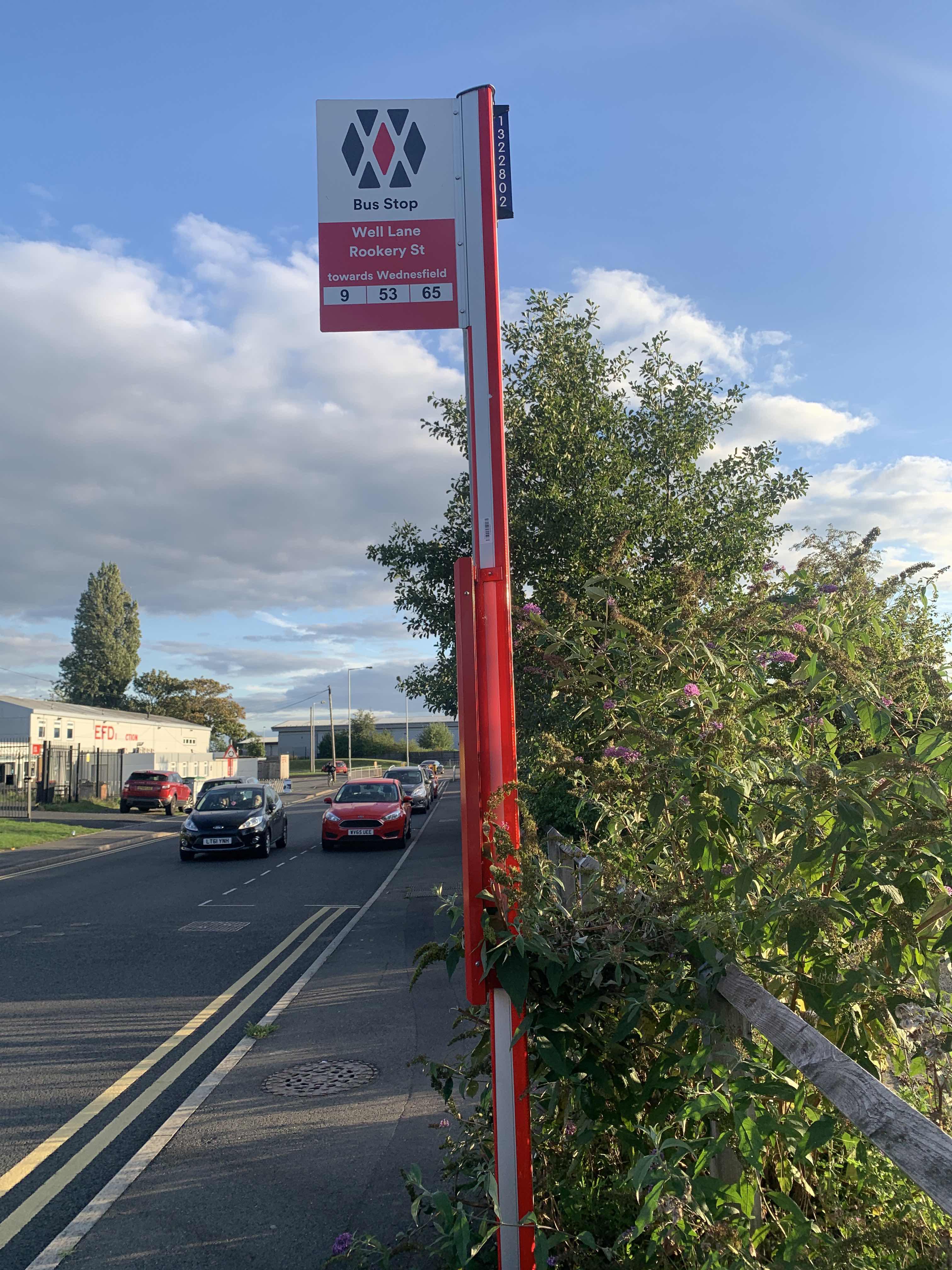 Taken by Anonymous
See Rookery St stop, Wednesfield South, on the map
Public transport to Rookery St stop (ID: nwmwtpwt) in Wednesfield South
Looking for directions to Rookery St in Wednesfield South, United Kingdom?
Download the Moovit App to find the current schedule and step-by-step directions for Bus or Train routes that pass through Rookery St.
Looking for the nearest stops closest to Rookery St ? Check out this list of closest stops to your destination: Rookery St; Bentley Bridge; St Thomas Church; Church St; Priestfield (West Midlands Metro); Wolverhampton.
Bus: 59, 9, 53, 65, 57, 71, 25, 65.Train: CROSSCOUNTRY, WEST MIDLANDS RAILWAY, AVANTI WEST COAST, TRANSPORT FOR WALES.
We make riding on public transit to Rookery St easy, which is why over 1.5 million users, including users in Wednesfield South trust Moovit as the best app for public transit.
Use the app to navigate to popular places including to the airport, hospital, stadium, grocery store, mall, coffee shop, school, college, and university.
Rookery St stop’s code is nwmwtpwt
The first line to this stop is 9, at 06:24, and the last line is 9 at 23:20.
Well Lane, Birmingham/Wolverhampton/Walsall/Dudley, England, United Kingdom
This stop serves National Express West Midlands, Let's Go and Banga Buses’s lines
- Rookery St,
- Bentley Bridge,
- St Thomas Church,
- Church St
Bus stops near Rookery St stop
- Priestfield (West Midlands Metro)
Light Rail station near Rookery St station
- Wolverhampton
Train station near Rookery St station
- The Cock Inn,
- Hamstead (Birmingham),
- Moorland Road,
- Bluebell Drive,
- Oxford,
- John Kyrle High School,
- Coventry Stadium,
- Little Sutton Rd,
- Rowley Regis Station,
- Acocks Green,
- Smiths Wood Academy,
- Boundary Drive,
- Engine Lane,
- Rowley Regis Station,
- Fox Hollies Rd,
- Stoke-On-Trent,
- Clifford Street,
- Ward Block (Entrance 1),
- Dudley Port,
- Douglas Macmillan Hospice
Popular public transport stations in Wednesfield South
Get around Wednesfield South by public transport!
Travelling around Wednesfield South has never been so easy. See step by step directions as you travel to any attraction, street or major public transport station. View bus and train timetables, arrival times, service alerts and detailed routes on a map, so you know exactly how to get to anywhere in Wednesfield South.
When travelling to any destination around Wednesfield South use Moovit's Live Directions with Get Off Notifications to know exactly where and how far to walk, how long to wait for your line , and how many stops are left. Moovit will alert you when it’s time to get off — no need to constantly re-check whether yours is the next stop.
Wondering how to use public transport in Wednesfield South or how to pay for public transport in Wednesfield South? Moovit public transport app can help you navigate your way with public transport easily, and at minimum cost. It includes public transport fees, ticket prices, and costs. Looking for a map of Wednesfield South public transport lines? Moovit public transport app shows all public transport maps in Wednesfield South with all Bus, Train and Light rail routes and stops on an interactive map.
West Midlands has 3 transport type(s), including: Bus, Train and Light rail, operated by several transport agencies, including National Express West Midlands, National Express Coventry, National Express, Diamond Bus, Arriva Midlands, Stagecoach Midlands, West Midlands Metro, Stagecoach West, Stagecoach South Wales, First Potteries, First Worcestershire, LandFlight, trentbarton, D & G Bus and Flexibus