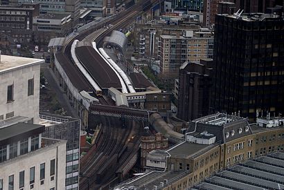
Waterloo East station - Thursday schedule
| Line | Direction | Time |
|---|---|---|
| SOUTHEASTERN | Gravesend | 05:23 |
| SOUTHEASTERN | Dartford | 05:28 |
| SOUTHEASTERN | Sevenoaks | 05:34 |
| SOUTHEASTERN | London Charing Cross | 05:35 |
| SOUTHEASTERN | London Charing Cross | 05:38 |
| SOUTHEASTERN | London Charing Cross | 05:45 |
| SOUTHEASTERN | Hayes (Kent) | 05:51 |
| SOUTHEASTERN | London Charing Cross | 05:51 |
| SOUTHEASTERN | Gravesend | 05:53 |
| SOUTHEASTERN | London Charing Cross | 05:55 |
| SOUTHEASTERN | Dartford | 05:58 |
| SOUTHEASTERN | London Charing Cross | 05:58 |
| SOUTHEASTERN | Hastings | 06:00 |
| SOUTHEASTERN | London Charing Cross | 06:02 |
| SOUTHEASTERN | Sevenoaks | 06:04 |
| SOUTHEASTERN | London Charing Cross | 06:06 |
| SOUTHEASTERN | London Charing Cross | 06:08 |
| SOUTHEASTERN | London Cannon Street | 06:09 |
| SOUTHEASTERN | London Charing Cross | 06:13 |
| SOUTHEASTERN | London Charing Cross | 06:16 |
| SOUTHEASTERN | Hayes (Kent) | 06:20 |
| SOUTHEASTERN | London Charing Cross | 06:21 |
| SOUTHEASTERN | Gravesend | 06:23 |
| SOUTHEASTERN | London Charing Cross | 06:25 |
| SOUTHEASTERN | Dartford | 06:28 |
Directions to Waterloo East station with public transport
The following transport lines have routes that pass near Waterloo East
How to get to Waterloo East station by bus?
Click on the bus route to see step by step directions with maps, line arrival times and updated time schedules.
How to get to Waterloo East station by train?
Click on the train route to see step by step directions with maps, line arrival times and updated time schedules.
How to get to Waterloo East station by Tube?
Click on the Tube route to see step by step directions with maps, line arrival times and updated time schedules.
Bus stops near Waterloo East stop
- Waterloo Station / Upper Taxi Road (A), 1 min walk,
- Waterloo Station / Waterloo Road (E), 1 min walk,
- Waterloo Station / Waterloo Road (D), 2 min walk,
- Waterloo Station / Mepham Street (E), 3 min walk,
- Waterloo Station / Waterloo Road (F), 3 min walk,
- London Waterloo, 4 min walk,
- Waterloo Road (L), 5 min walk,
Tube stations near Waterloo East station
- Waterloo, 2 min walk,
River Bus stations near Waterloo East station
- Festival Pier, 7 min walk,
- London Eye Waterloo Pier, 13 min walk,
Bus lines to Waterloo East station
- 11, Fulham Broadway,
- 77, Waterloo,
- 1, Canada Water - Hampstead Heath,
- N1, Thamesmead - Tottenham Court Road,
- C10, Victoria - Canada Water Bus Station,
- 139, Waterloo - Golders Green,
- 188, Tottenham Court Road - North Greenwich,
- 341, Waterloo - Meridian Water, Glover Drive Superstores,
- SL6, West Croydon,
- 59, Smithfield, St Bartholomew's Hospital,
- 68, Euston,
- N68, Tottenham Court Road,
- N171, Hither Green Station,
- 172, Aldwych,
- 176, Penge,
- 243, Waterloo,
- 76, Tottenham Hale,
- SOUTH WESTERN RAILWAY, Frome,
- SOUTH WESTERN RAILWAY, Bus Replacement: Twickenham,
- N343, New Cross Gate,
What are the nearest stations to Waterloo East?
The nearest stations to Waterloo East are:
- Waterloo Station / Upper Taxi Road (A) is 27 meters away, 1 min walk.
- Waterloo Station / Waterloo Road (E) is 51 meters away, 1 min walk.
- Waterloo is 96 meters away, 2 min walk.
- Waterloo Station / Waterloo Road (D) is 133 meters away, 2 min walk.
- Waterloo Station / Mepham Street (E) is 194 meters away, 3 min walk.
- Waterloo Station / Waterloo Road (F) is 212 meters away, 3 min walk.
- London Waterloo is 288 meters away, 4 min walk.
- Waterloo Road (L) is 306 meters away, 5 min walk.
- Festival Pier is 498 meters away, 7 min walk.
- London Eye Waterloo Pier is 967 meters away, 13 min walk.
Which bus lines stop near Waterloo East?
These bus lines stop near Waterloo East: 101, 149, 164, 21, 276, 37, 47, 66, A7, R3, S4, W5, W8.
Which train lines stop near Waterloo East?
These train lines stop near Waterloo East: SOUTH WESTERN RAILWAY, SOUTHEASTERN, THAMESLINK.
Which Tube line stops near Waterloo East?
NORTHERN (Kennington via Charing Cross)
What’s the nearest Tube station to Waterloo East?
The nearest Tube station to Waterloo East is Waterloo. It’s a 2 min walk away.
What’s the nearest bus station to Waterloo East?
The nearest bus stations to Waterloo East are Waterloo Station / Upper Taxi Road (A) and Waterloo Station / Waterloo Road (E). The closest one is a 1 min walk away.
What’s the nearest River Bus station to Waterloo East?
The nearest River Bus station to Waterloo East is Festival Pier. It’s a 7 min walk away.
What time is the first Tube to Waterloo East?
The JUBILEE is the first Tube that goes to Waterloo East. It stops nearby at 03:26.
What time is the last Tube to Waterloo East?
The JUBILEE is the last Tube that goes to Waterloo East. It stops nearby at 00:51.
What time is the first train to Waterloo East?
The SOUTH WESTERN RAILWAY is the first train that goes to Waterloo East. It stops nearby at 06:14.
What time is the last train to Waterloo East?
The SOUTH WESTERN RAILWAY is the last train that goes to Waterloo East. It stops nearby at 01:44.
What time is the first bus to Waterloo East?
The N68 is the first bus that goes to Waterloo East. It stops nearby at 03:01.
What time is the last bus to Waterloo East?
The 243 is the last bus that goes to Waterloo East. It stops nearby at 04:13.
What time is the first River Bus to Waterloo East?
The RB6 is the first River Bus that goes to Waterloo East. It stops nearby at 21:03.
What time is the last River Bus to Waterloo East?
The RB6 is the last River Bus that goes to Waterloo East. It stops nearby at 23:33.
See Waterloo East station on the map
Public transport to Waterloo East station
Looking for directions to Waterloo East in Waterloo, United Kingdom?
Download the Moovit App to find the current schedule and step-by-step directions for Bus, Train or Tube routes that pass through Waterloo East.
Looking for the nearest stops closest to Waterloo East ? Check out this list of closest stops to your destination: Waterloo Station / Upper Taxi Road (A); Waterloo Station / Waterloo Road (E); Waterloo; Waterloo Station / Waterloo Road (D); Waterloo Station / Mepham Street (E); Waterloo Station / Waterloo Road (F); London Waterloo; Waterloo Road (L); Festival Pier; London Eye Waterloo Pier.
Bus: 101, 149, 164, 21, 276, 37, 47, 66, A7, R3, S4, W5, W8, 11, 77, 1, N1, C10, 139, 188, SL6, 59, 68, N68, N171, 243.Train: SOUTH WESTERN RAILWAY, SOUTHEASTERN, THAMESLINK.Tube: NORTHERN, BAKERLOO, JUBILEE, WATERLOO & CITY.River Bus: THAMES RIVER SERVICES.
We make riding on public transit to Waterloo East easy, which is why over 1.5 million users, including users in Waterloo trust Moovit as the best app for public transit.
Use the app to navigate to popular places including to the airport, hospital, stadium, grocery store, mall, coffee shop, school, college, and university.
The station has the following entrances: Entrance Via Waterloo, Sandell Street Entrance, Brad Street and Greet Street
The first line to this station is SOUTHEASTERN, at 05:23, and the last line is SOUTHEASTERN at 00:53.
Wootton Street, London, England, United Kingdom
This station serves National Rail’s lines
Popular routes from Waterloo East station
Bus stops near Waterloo East stop
Tube station near Waterloo East station
Popular public transport stations in Waterloo
Get around Waterloo by public transport!
Travelling around Waterloo has never been so easy. See step by step directions as you travel to any attraction, street or major public transport station. View bus and train timetables, arrival times, service alerts and detailed routes on a map, so you know exactly how to get to anywhere in Waterloo.
When travelling to any destination around Waterloo use Moovit's Live Directions with Get Off Notifications to know exactly where and how far to walk, how long to wait for your line , and how many stops are left. Moovit will alert you when it’s time to get off — no need to constantly re-check whether yours is the next stop.
Wondering how to use public transport in Waterloo or how to pay for public transport in Waterloo? Moovit public transport app can help you navigate your way with public transport easily, and at minimum cost. It includes public transport fees, ticket prices, and costs. Looking for a map of Waterloo public transport lines? Moovit public transport app shows all public transport maps in Waterloo with all Bus, Train, Tube, Tramlink, River Bus and DLR routes and stops on an interactive map.
London has 6 transport type(s), including: Bus, Train, Tube, Tramlink, River Bus and DLR, operated by several transport agencies, including London Buses, Transport for London, London Underground, London River Services, National Rail, Luton Airport Shuttle, Bayliss Executive Travel, Edward Thomas, Metrobus, Coggeshall Community Bus, Tendring Community Transport, Sullivan Buses, Z & S Transport, Central Connect and Compass Travel