The Most Popular Urban Mobility App in Sydney.
All local mobility options in one app
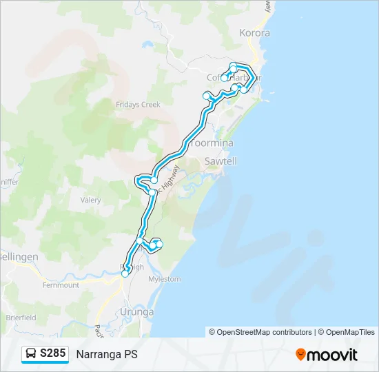
The S285 (Narranga PS) has 12 stations departing from Giinagay Way after Waterfall Way and ending at Narranga Public School, Robin St.
S285 time schedule overview for the upcoming week: It departs once a day at 07:36. Operating days this week: weekdays.
Choose any of the S285 stations below to find updated real-time schedules and to see their route map.
Services on the S285 start at 07:36 on Monday, Tuesday, Wednesday, Thursday, Friday.
Services on the S285 stop at 07:36 on Monday, Tuesday, Wednesday, Thursday, Friday.
When does the Narranga PS line come? Check Live Arrival Times for live arrival times and to see the full schedule for the Narranga PS line that is closest to your location.
Click here to view the nearest S285 station.
S285 line operates on weekdays. Regular schedule hours: 07:36
| Day | Operating Hours | Frequency (min) |
|---|---|---|
| Mon | 07:36 | Single departure |
| Tue | 07:36 | Single departure |
| Wed | 07:36 | Single departure |
| Thu | 07:36 | Single departure |
| Fri | 07:36 | Single departure |
| Sat | Not Operational | Not Operational |
| Sun | Not Operational | Not Operational |
See all updates on S285 (from Giinagay Way after Waterfall Way), including real-time status info, delays, changes of routes, changes of stops locations, and any other service changes. Get a real-time map view of S285 (Narranga PS) and track the as it moves on the map. Download the app for all info now.
Busways S285 (Narranga PS) prices may change based on several factors. For more information about Busways tickets costs please check the Moovit app or ’s official website.
The first stop of the S285 route is Giinagay Way after Waterfall Way and the last stop is Narranga Public School, Robin St. S285 (Narranga PS) is operational during weekdays.
Additional information: S285 has 12 stations and the total trip duration for this route is approximately 83 minutes.
On the go? See why over 1.5 million users trust Moovit as the best public transport app. Moovit gives you Busways suggested routes, real-time tracker, live directions, line route maps in Sydney, and helps to find the closest S285 stations near you. No internet available? Download an offline PDF map and schedule for the S285 to take on your trip.
Track line S285 (Narranga PS) on a live map in real time and follow its location as it moves between stations. Use Moovit as a line S285 tracker or a live Busways tracker app and never miss your .
Use the app as a trip planner for Busways or a trip planner for metro, train, light rail, ferry or bus to plan your route around Sydney. The trip planner shows updated data for Busways and any , including line S285, in Sydney