Amsterdam, Centraal Station stop - Tuesday schedule
| Line | Direction | Time |
|---|---|---|
| N23 | Amsterdam Cs | 01:55 |
| N23 | Almere Stad | 02:26 |
| N23 | Amsterdam Cs | 02:58 |
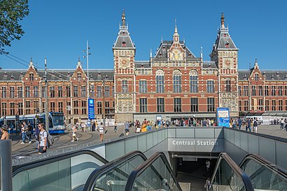
Directions to Amsterdam, Centraal Station with public transportation
The following transit lines have routes that pass near Amsterdam, Centraal Station
How to get to Amsterdam, Centraal Station by bus?
Click on the bus route to see step by step directions with maps, line arrival times and updated time schedules.
How to get to Amsterdam, Centraal Station by train?
Click on the train route to see step by step directions with maps, line arrival times and updated time schedules.
How to get to Amsterdam, Centraal Station by metro?
Click on the metro route to see step by step directions with maps, line arrival times and updated time schedules.
Bus stops near Amsterdam, Centraal Station
- Centraal Station, 1 min walk,
- Amsterdam, Centraal Station (Perron A), 2 min walk,
- P. Hendrikkade (Uitstaphalte), 6 min walk,
- Prins Hendrikkade, 6 min walk,
- Amsterdam, Centraal Station (Perron H), 7 min walk,
- Amsterdam, Centraal Station (Perron J), 7 min walk,
- Amsterdam, Centraal Station, 8 min walk,
Train stations near Amsterdam, Centraal Station
- Amsterdam Centraal, 1 min walk,
- [Amsterdam Centraal] Busstation Ij-Zijde, Bushalte M, 2 min walk,
Ferry stations near Amsterdam, Centraal Station
- Centraal Station, 2 min walk,
Light Rail stations near Amsterdam, Centraal Station
- Centraal Station, 11 min walk,
Bus lines to Amsterdam, Centraal Station
- N85, Lijn 285,
- N86, Lijn 286,
- N87, Lijn 287,
- N11, Marken Via Monnickendam,
- N14, Edam,
- 314, Amsterdam Centraal,
- 316, Amsterdam Centraal Via Volendam,
- N06, Amsterdam Centraal - Purmerend Overwhere,
- N07, Amsterdam Centraal - Purmerend De Purmer,
- N19, Amsterdam Centraal via Oostzaan - Zaandam,
- N94, Amsterdam Centraal via Zaandam - Krommenie,
- 305, Amsterdam Noord via Purmerend - De Rijp,
- 391, Zaandam Zaanse Schans - Amsterdam Noorderpark,
- 22, Station Sloterdijk,
- N91, Centraal Station,
- N93, Molenwijk,
- 48, Centraal Station,
- 801, Amsterdam Centraal,
- N47, Amsterdam Centraal Station,
- N57, Aalsmeer Busst.,
What are the closest stations to Amsterdam, Centraal Station?
The closest stations to Amsterdam, Centraal Station are:
- Centraal Station is 47 meters away, 1 min walk.
- Amsterdam Centraal is 56 meters away, 1 min walk.
- [Amsterdam Centraal] Busstation Ij-Zijde, Bushalte M is 78 meters away, 2 min walk.
- Amsterdam, Centraal Station (Perron A) is 97 meters away, 2 min walk.
- P. Hendrikkade (Uitstaphalte) is 409 meters away, 6 min walk.
- Prins Hendrikkade is 420 meters away, 6 min walk.
- Amsterdam, Centraal Station (Perron H) is 499 meters away, 7 min walk.
- Amsterdam, Centraal Station (Perron J) is 521 meters away, 7 min walk.
- Amsterdam, Centraal Station is 572 meters away, 8 min walk.
Which bus lines stop near Amsterdam, Centraal Station?
These bus lines stop near Amsterdam, Centraal Station: 18, 21, 22, 305.
Which train lines stop near Amsterdam, Centraal Station?
These train lines stop near Amsterdam, Centraal Station: IC, SPR.
Which metro lines stop near Amsterdam, Centraal Station?
These metro lines stop near Amsterdam, Centraal Station: 51, 54.
Which light rail line stops near Amsterdam, Centraal Station?
2 (Centraal Station)
What’s the nearest light rail station to Amsterdam, Centraal Station?
The nearest light rail station to Amsterdam, Centraal Station is Centraal Station. It’s a 11 min walk away.
What’s the nearest train station to Amsterdam, Centraal Station?
The nearest train station to Amsterdam, Centraal Station is Amsterdam Centraal. It’s a 1 min walk away.
What’s the nearest bus station to Amsterdam, Centraal Station?
The nearest bus station to Amsterdam, Centraal Station is Centraal Station. It’s a 1 min walk away.
What’s the nearest ferry station to Amsterdam, Centraal Station?
The nearest ferry station to Amsterdam, Centraal Station is Centraal Station. It’s a 2 min walk away.
What time is the first light rail to Amsterdam, Centraal Station?
The 26 is the first light rail that goes to Amsterdam, Centraal Station. It stops nearby at 5:56 AM.
What time is the last light rail to Amsterdam, Centraal Station?
The 26 is the last light rail that goes to Amsterdam, Centraal Station. It stops nearby at 12:40 AM.
What time is the first train to Amsterdam, Centraal Station?
The IC is the first train that goes to Amsterdam, Centraal Station. It stops nearby at 3:19 AM.
What time is the last train to Amsterdam, Centraal Station?
The NIGHTJET is the last train that goes to Amsterdam, Centraal Station. It stops nearby at 10:49 AM.
What time is the first bus to Amsterdam, Centraal Station?
The N85 is the first bus that goes to Amsterdam, Centraal Station. It stops nearby at 3:13 AM.
What time is the last bus to Amsterdam, Centraal Station?
The N97 is the last bus that goes to Amsterdam, Centraal Station. It stops nearby at 3:59 AM.
What time is the first ferry to Amsterdam, Centraal Station?
The F3 is the first ferry that goes to Amsterdam, Centraal Station. It stops nearby at 3:08 AM.
What time is the last ferry to Amsterdam, Centraal Station?
The F3 is the last ferry that goes to Amsterdam, Centraal Station. It stops nearby at 2:58 AM.
See Amsterdam, Centraal Station on the map
Public transit to Amsterdam, Centraal Station stop (ID: 57005100)
Looking for directions to Amsterdam, Centraal Station in Amsterdam, Netherlands?
Download the Moovit App to find the current schedule and step-by-step directions for Bus, Metro, Train or Light Rail routes that pass through Amsterdam, Centraal Station.
Looking for the nearest stops closest to Amsterdam, Centraal Station ? Check out this list of closest stops to your destination: Centraal Station; Amsterdam Centraal; [Amsterdam Centraal] Busstation Ij-Zijde; Amsterdam, Centraal Station (Perron A); P. Hendrikkade (Uitstaphalte); Prins Hendrikkade; Amsterdam, Centraal Station (Perron H); Amsterdam, Centraal Station (Perron J); Amsterdam, Centraal Station.
Bus: 18, 21, 22, 305, N85, N86, N87, N11, N14, 314, 316, N06, N07, N19, N94.Train: IC, SPR, EUROPEAN SLEEPER, EUROSTAR, EUROSTAR, EUROSTAR, SNELBUS IPV TREIN, STOPBUS IPV TREIN, STOPBUS IPV TREIN.Metro: 51, 54.Light Rail: 2.Ferry: F3.
We make riding on public transit to Amsterdam, Centraal Station easy, which is why over 1.5 million users, including users in Amsterdam trust Moovit as the best app for public transit.
Use the app to navigate to popular places including to the airport, hospital, stadium, grocery store, mall, coffee shop, school, college, and university.
Amsterdam, Centraal Station stop’s code is 57005100
The first line to this stop is N23, at 01:55, and the last line is N23 at 02:58.
IJ-hal, Amsterdam, Netherlands
This stop serves allGo’s lines
Popular routes from Amsterdam, Centraal Station
Bus stops near Amsterdam, Centraal Station
Train stations near Amsterdam, Centraal Station
Ferry station near Amsterdam, Centraal Station
Light Rail station near Amsterdam, Centraal Station
Popular public transit stations in Amsterdam
Get around Amsterdam by public transit!
Traveling around Amsterdam has never been so easy. See step by step directions as you travel to any attraction, street or major public transit station. View bus and train schedules, arrival times, service alerts and detailed routes on a map, so you know exactly how to get to anywhere in Amsterdam.
When traveling to any destination around Amsterdam use Moovit's Live Directions with Get Off Notifications to know exactly where and how far to walk, how long to wait for your line, and how many stops are left. Moovit will alert you when it's time to get off — no need to constantly re-check whether yours is the next stop.
Wondering how to use public transit in Amsterdam or how to pay for public transit in Amsterdam? Moovit public transit app can help you navigate your way with public transit easily, and at minimum cost. It includes public transit fees, ticket prices, and costs. Looking for a map of Amsterdam public transit lines? Moovit public transit app shows all public transit maps in Amsterdam with all Bus, Train, Metro, Light Rail and Ferry routes and stops on an interactive map.
Netherlands has 5 transit type(s), including: Bus, Train, Metro, Light Rail and Ferry, operated by several transit agencies, including Arriva, Breng, Connexxion, EBS, Bravo (Hermes), HTM, DB, NMBS, NS, Qbuzz, RET, Rederij Doeksen, R-net, TESO and Wagenborg Passagiersdiensten