Atlalilco station - Tuesday schedule
| Line | Direction | Time |
|---|---|---|
| 12 | Dirección Tláhuac | 5:20 |
| 12 | Dirección Tláhuac | 5:24 |
| 12 | Dirección Tláhuac | 5:28 |
| 12 | Dirección Mixcoac | 5:29 |
| 12 | Dirección Tláhuac | 5:32 |
| 12 | Dirección Mixcoac | 5:33 |
| 8 | Dirección Constitución de 1917 | 5:34 |
| 12 | Dirección Tláhuac | 5:36 |
| 12 | Dirección Mixcoac | 5:37 |
| 8 | Dirección Constitución de 1917 | 5:38 |
| 12 | Dirección Tláhuac | 5:40 |
| 12 | Dirección Mixcoac | 5:41 |
| 8 | Dirección Constitución de 1917 | 5:42 |
| 12 | Dirección Tláhuac | 5:44 |
| 12 | Dirección Mixcoac | 5:45 |
| 8 | Dirección Constitución de 1917 | 5:46 |
| 12 | Dirección Tláhuac | 5:48 |
| 12 | Dirección Mixcoac | 5:49 |
| 8 | Dirección Constitución de 1917 | 5:50 |
| 12 | Dirección Tláhuac | 5:52 |
| 12 | Dirección Mixcoac | 5:53 |
| 8 | Dirección Constitución de 1917 | 5:54 |
| 12 | Dirección Tláhuac | 5:56 |
| 12 | Dirección Mixcoac | 5:57 |
| 8 | Dirección Constitución de 1917 | 5:58 |
Directions to Atlalilco station (Benito Juárez) with public transit
The following transit lines have routes that pass near Atlalilco
How to get to Atlalilco station by bus?
Click on the bus route to see step by step directions with maps, line arrival times and updated time schedules.
How to get to Atlalilco station by metro?
Click on the metro route to see step by step directions with maps, line arrival times and updated time schedules.
Bus stops near Atlalilco stop in Benito Juárez
- Metro Atallilco, 1 min walk,
- Ermita I. Y Metro Atlalilco, 1 min walk,
- Calz. Ermita Iztapalapa - Metro Atlalilco, 1 min walk,
- Metro Atlalilco, 1 min walk,
- Ermita Iztapakaoa - Puente Titla, 4 min walk,
Metro stations near Atlalilco station in Benito Juárez
- Cerro de La Estrella, 22 min walk,
- Mexicaltzingo, 36 min walk,
Bus lines to Atlalilco station in Benito Juárez
- RUTA 56 - RUTA 12, Unidad San Marcos,
- 6A, Barranca del Muerto - Ermita,
- 1-D, C. C. Metro Mixcoac,
- 52-C, C. C. Metro Zapata - Av. Universidad/San Lorenzo,
- 1, Vicente Guerrero,
- RUTA 1, Col. Progresista,
- RUTA 14, Merced,
- RUTA 14, Metro Portales,
- RUTA 25, Col. El Manto,
- RUTA 27, Hank Gonzales,
- RUTA 33, Metro Atlalilco,
- RUTA 37, Metro Constitución,
- RUTA 74, Miravalle,
- 101, Metro Zapata,
- 128, Santa Cruz,
- 131, Coyoacan,
- 132, Iztapalapa,
- 133, San Angel,
- 134, Santa Cruz,
- 156, Colonia Morelos,
What are the closest stations to Atlalilco?
The closest stations to Atlalilco are:
- Metro Atallilco is 14 meters away, 1 min walk.
- Ermita I. Y Metro Atlalilco is 15 meters away, 1 min walk.
- Calz. Ermita Iztapalapa - Metro Atlalilco is 16 meters away, 1 min walk.
- Metro Atlalilco is 16 meters away, 1 min walk.
- Ermita Iztapakaoa - Puente Titla is 245 meters away, 4 min walk.
- Cerro de La Estrella is 1641 meters away, 22 min walk.
- Mexicaltzingo is 2816 meters away, 36 min walk.
Which bus lines stop near Atlalilco?
These bus lines stop near Atlalilco: 128, 160, 6A, RUTA 1, RUTA 37.
Which metro lines stop near Atlalilco?
These metro lines stop near Atlalilco: 12, 8.
What’s the nearest metro station to Atlalilco in Benito Juárez?
The nearest metro station to Atlalilco in Benito Juárez is Cerro de La Estrella. It’s a 22 min walk away.
What’s the nearest bus station to Atlalilco in Benito Juárez?
The nearest bus stations to Atlalilco in Benito Juárez are Metro Atallilco, Ermita I. Y Metro Atlalilco, Calz. Ermita Iztapalapa - Metro Atlalilco and Metro Atlalilco. The closest one is a 1 min walk away.
What time is the first metro to Atlalilco in Benito Juárez?
The 8 is the first metro that goes to Atlalilco in Benito Juárez. It stops nearby at 5:06 AM.
What time is the last metro to Atlalilco in Benito Juárez?
The 8 is the last metro that goes to Atlalilco in Benito Juárez. It stops nearby at 12:37 AM.
What time is the first bus to Atlalilco in Benito Juárez?
The RUTA 1 is the first bus that goes to Atlalilco in Benito Juárez. It stops nearby at 4:04 AM.
What time is the last bus to Atlalilco in Benito Juárez?
The 52-C is the last bus that goes to Atlalilco in Benito Juárez. It stops nearby at 1:57 AM.
See Atlalilco station, Benito Juárez, on the map
Public transit to Atlalilco station in Benito Juárez
Looking for directions to Atlalilco in Benito Juárez, México?
Download the Moovit App to find the current schedule and step-by-step directions for Bus or Metro routes that pass through Atlalilco.
Looking for the nearest stops closest to Atlalilco ? Check out this list of closest stops to your destination: Metro Atallilco; Ermita I. Y Metro Atlalilco; Calz. Ermita Iztapalapa - Metro Atlalilco; Metro Atlalilco; Ermita Iztapakaoa - Puente Titla; Cerro de La Estrella; Mexicaltzingo.
Bus: 128, 160, 6A, RUTA 1, RUTA 37, RUTA 56 - RUTA 12, 1-D, 52-C, 1, RUTA 14, RUTA 14, RUTA 25.Metro: 12, 8.
We make riding on public transit to Atlalilco easy, which is why over 1.5 million users, including users in Benito Juárez trust Moovit as the best app for public transit.
Use the app to navigate to popular places including to the airport, hospital, stadium, grocery store, mall, coffee shop, school, college, and university.
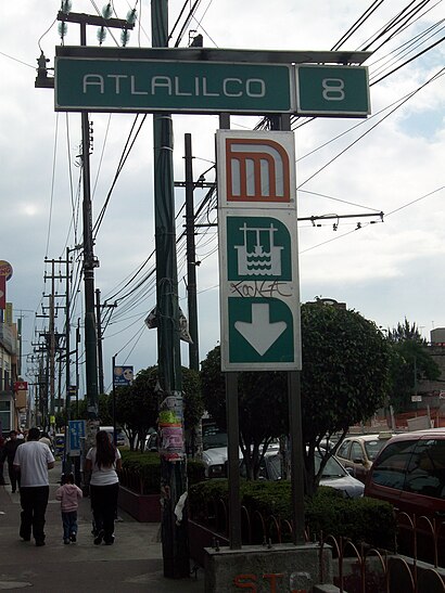
The station has the following entrances: Ermita Iztapalapa (Oxxo) and Ermita Iztapalapa
The first line to this station is 12, at 5:20, and the last line is 8 at 0:32.
This station serves STC (Metro CDMX)’s lines
Bus stops near Atlalilco stop
Popular public transit stations in Benito Juárez
Get around Benito Juárez by public transit!
Traveling around Benito Juárez has never been so easy. See step by step directions as you travel to any attraction, street or major public transit station. View bus and train schedules, arrival times, service alerts and detailed routes on a map, so you know exactly how to get to anywhere in Benito Juárez.
When traveling to any destination around Benito Juárez use Moovit's Live Directions with Get Off Notifications to know exactly where and how far to walk, how long to wait for your line, and how many stops are left. Moovit will alert you when it's time to get off — no need to constantly re-check whether yours is the next stop.
Wondering how to use public transit in Benito Juárez or how to pay for public transit in Benito Juárez? Moovit public transit app can help you navigate your way with public transit easily, and at minimum cost. It includes public transit fees, ticket prices, and costs. Looking for a map of Benito Juárez public transit lines? Moovit public transit app shows all public transit maps in Benito Juárez with all Bus, Train, Metro, Cable Car and Gondola routes and stops on an interactive map.
Ciudad de Mexico has 5 transit type(s), including: Bus, Train, Metro, Cable Car and Gondola, operated by several transit agencies, including STC (Metro CDMX), Ferrocarriles Suburbanos, Trolebús, Puma Bus, Mexibus, Autobuses / Combis, Tren Ligero, Mexicable, Peseros, Cablebús, Trolebús elevado, Corredores Concesionados, RTP, Metrobús and Tren El Insurgente