Directions to Calle 40i Sur station (Rafael Uribe) with public transit
The following transit lines have routes that pass near Calle 40i Sur
How to get to Calle 40i Sur station by bus?
Click on the bus route to see step by step directions with maps, line arrival times and updated time schedules.
How to get to Calle 40i Sur station by cable car?
Click on the cable car route to see step by step directions with maps, line arrival times and updated time schedules.
Bus stops near Calle 40i Sur in Rafael Uribe
- Br. San Jorge Sur (Cl 43 Sur - Tv 15a), 4 min walk,
- Br. Marco Fidel Suárez (Dg 45f Sur - Tv 14 Bis), 7 min walk,
- Br. Marco Fidel Suárez I (Dg 46 Sur - Kr 16a) (A), 7 min walk,
- Br. Las Colinas (Dg 32h Sur - Kr 15a), 9 min walk,
Cable Car stations near Calle 40i Sur in Rafael Uribe
- Quiroga, 5 min walk,
- Socorro, 8 min walk,
- Santa Lucía, 22 min walk,
- Calle 40 Sur, 25 min walk,
Bus lines to Calle 40i Sur station in Rafael Uribe
- 271, Gran Granada,
- K328, Puerta De Teja,
- H636, Rincón De Venecia,
- 7-1, Uribe Uribe [A.M.],
- 271, Lomas,
- L328, Estación Avenida 1° De Mayo,
- L636, San Blas II,
- D205, Bachué,
- 13-13, Resurrección,
What are the closest stations to Calle 40i Sur?
The closest stations to Calle 40i Sur are:
- Br. San Jorge Sur (Cl 43 Sur - Tv 15a) is 290 meters away, 4 min walk.
- Quiroga is 331 meters away, 5 min walk.
- Br. Marco Fidel Suárez (Dg 45f Sur - Tv 14 Bis) is 525 meters away, 7 min walk.
- Br. Marco Fidel Suárez I (Dg 46 Sur - Kr 16a) (A) is 543 meters away, 7 min walk.
- Socorro is 562 meters away, 8 min walk.
- Br. Las Colinas (Dg 32h Sur - Kr 15a) is 686 meters away, 9 min walk.
- Santa Lucía is 1663 meters away, 22 min walk.
- Calle 40 Sur is 1948 meters away, 25 min walk.
Which bus lines stop near Calle 40i Sur?
These bus lines stop near Calle 40i Sur: 271, H721, K328, L328, L636.
Which cable car lines stop near Calle 40i Sur?
These cable car lines stop near Calle 40i Sur: H21, H27, H54.
What’s the nearest bus station to Calle 40i Sur in Rafael Uribe?
The nearest bus station to Calle 40i Sur in Rafael Uribe is Br. San Jorge Sur (Cl 43 Sur - Tv 15a). It’s a 4 min walk away.
What’s the nearest cable car station to Calle 40i Sur in Rafael Uribe?
The nearest cable car station to Calle 40i Sur in Rafael Uribe is Quiroga. It’s a 5 min walk away.
What time is the first bus to Calle 40i Sur in Rafael Uribe?
The D205 is the first bus that goes to Calle 40i Sur in Rafael Uribe. It stops nearby at 3:02 AM.
What time is the last bus to Calle 40i Sur in Rafael Uribe?
The 7-2 is the last bus that goes to Calle 40i Sur in Rafael Uribe. It stops nearby at 12:41 AM.
What time is the first cable car to Calle 40i Sur in Rafael Uribe?
The D21 is the first cable car that goes to Calle 40i Sur in Rafael Uribe. It stops nearby at 4:03 AM.
What time is the last cable car to Calle 40i Sur in Rafael Uribe?
The H15 is the last cable car that goes to Calle 40i Sur in Rafael Uribe. It stops nearby at 11:40 PM.
See Calle 40i Sur, Rafael Uribe, on the map
Public Transit to Calle 40i Sur in Rafael Uribe
How to get to Calle 40i Sur in Rafael Uribe, Colombia?
It’s easy with Moovit. Type in your street address and Moovit’s route finder will locate the fastest way to get you there! Not sure where to get off on the street? Download the Moovit App to find live directions (including where to get off on Calle 40i Sur), see timetables and get the estimated arrival times for your favorite bus or cable car lines.
Looking for the nearest stop or station to Calle 40i Sur? Check out this list of closest stops available to your destination: Br. San Jorge Sur (Cl 43 Sur - Tv 15a); Quiroga; Br. Marco Fidel Suárez (Dg 45f Sur - Tv 14 Bis); Br. Marco Fidel Suárez I (Dg 46 Sur - Kr 16a) (A); Socorro; Br. Las Colinas (Dg 32h Sur - Kr 15a); Santa Lucía; Calle 40 Sur.
Bus: 271, H721, K328, L328, L636, H636, 7-1, D205, 13-13.Cable Car: H21, H27, H54, 3, 3, B13, H13, C17, B72, H72.
Download the Moovit App to see the current schedule and routes available for Rafael Uribe. No need to install a special bus app to check the bus time or a train app to get train time. Moovit is the only all-in-one transit app that helps you get where you need to go.
We make riding on public transit to Calle 40i Sur easy, which is why over 1.5 million users, including users in Rafael Uribe trust Moovit as the best app for public transit.
Use the app to navigate to popular places including to the airport, hospital, stadium, grocery store, mall, coffee shop, school, college, and university.
Location: Rafael Uribe, Bogota
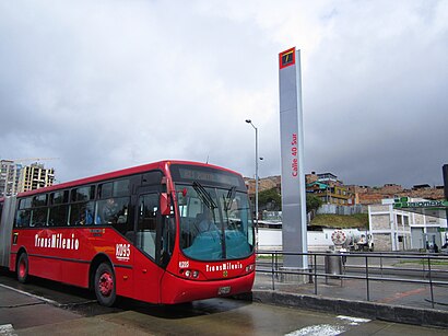
The intermediate station Calle 40 Sur is part of the TransMilenio mass-transit system of Bogotá, Colombia, opened in the year 2000.Wiki
Streets near Calle 40i Sur, Rafael Uribe
Get around Rafael Uribe by public transit!
Traveling around Rafael Uribe has never been so easy. See step by step directions as you travel to any attraction, street or major public transit station. View bus and train schedules, arrival times, service alerts and detailed routes on a map, so you know exactly how to get to anywhere in Rafael Uribe.
When traveling to any destination around Rafael Uribe use Moovit's Live Directions with Get Off Notifications to know exactly where and how far to walk, how long to wait for your line, and how many stops are left. Moovit will alert you when it's time to get off — no need to constantly re-check whether yours is the next stop.
Wondering how to use public transit in Rafael Uribe or how to pay for public transit in Rafael Uribe? Moovit public transit app can help you navigate your way with public transit easily, and at minimum cost. It includes public transit fees, ticket prices, and costs. Looking for a map of Rafael Uribe public transit lines? Moovit public transit app shows all public transit maps in Rafael Uribe with all Bus, Cable Car and Funicular routes and stops on an interactive map.
Bogota has 3 transit type(s), including: Bus, Cable Car and Funicular, operated by several transit agencies, including Buses Troncales, TransMiZonal, Cerro de Monserrate, Aeropuerto El Dorado, TransMiCable, Flota Chia Ltda., Auto Servicio Chía Ltda. and Cootranscajicá Ltda.