Directions to Caloocan Pnr Station station (Kalookan City) with public transit
The following transit lines have routes that pass near Caloocan Pnr Station
How to get to Caloocan Pnr Station station by bus?
Click on the bus route to see step by step directions with maps, line arrival times and updated time schedules.
How to get to Caloocan Pnr Station station by train?
Click on the train route to see step by step directions with maps, line arrival times and updated time schedules.
Train station near Caloocan Pnr Station in Kalookan City
- R. Papa Lrt, 2 min walk,
Bus stops near Caloocan Pnr Station in Kalookan City
- Caloocan Central Fire Station, Samson Road, Caloocan City, 4 min walk,
- Jollibee, Samson Road, Caloocan City, 4 min walk,
- Caloocan City Police Station, Samson Road, Malabon City, 6 min walk,
- P. Bonifacio Street / Caimito Road Intersection, Malabon City, 13 min walk,
Bus lines to Caloocan Pnr Station station in Kalookan City
- BUS, Navotas Terminal Pacita Complex via EDSA,
- BUS, Baclaran Malabon (Letre) via EDSA,
- BUS, Baclaran Navotas via Ayala,
- BUS, Ayala UE Caloocan via EDSA,
- BUS, Alabang Navotas,
- BUS, Ayala Malabon via EDSA,
- BUS, Alabang Malabon (Letre) via EDSA,
- BUS, Taguig City Navotas,
- JEEP, Monumento - Navotas via Letre,
- JEEP, Malabon - Monumento via Letre,
- JEEP, MCU - Sangandaan,
- JEEP, MONUMENTO-MALABON via LETRE,
- BUS, Pala - pala Dasmarinas Cavite - Navotas Terminal via Edsa,
- BUS, Baclaran-Navotas Terminal via Edsa Ayala,
- BUS, FTI - Navotas Terminal via EDSA,
- BUS, Pacita Complex (SP, Lag) - Letre via EDSA,
- JEEP, Divisoria - Sangandaan via Maypajo,
- JEEP, DIVISORIA - SANGANDAAN,
- JEEP, San Diego De Alcala Parish, Palassan Road, Kapitan Viilila, Valenzuela City,
- JEEP, Sto Rosario Parish, Don Bastilio Bautista Boulevard, Malabon City,
What are the closest stations to Caloocan Pnr Station?
The closest stations to Caloocan Pnr Station are:
- R. Papa Lrt is 134 meters away, 2 min walk.
- Caloocan Central Fire Station, Samson Road, Caloocan City is 212 meters away, 4 min walk.
- Jollibee, Samson Road, Caloocan City is 276 meters away, 4 min walk.
- Caloocan City Police Station, Samson Road, Malabon City is 384 meters away, 6 min walk.
- P. Bonifacio Street / Caimito Road Intersection, Malabon City is 901 meters away, 13 min walk.
Which bus lines stop near Caloocan Pnr Station?
These bus lines stop near Caloocan Pnr Station: BUS, JEEP.
Which train line stops near Caloocan Pnr Station?
LRT 1 (Roosevelt)
What’s the nearest train station to Caloocan Pnr Station in Kalookan City?
The nearest train station to Caloocan Pnr Station in Kalookan City is R. Papa Lrt. It’s a 2 min walk away.
What’s the nearest bus station to Caloocan Pnr Station in Kalookan City?
The nearest bus stations to Caloocan Pnr Station in Kalookan City are Caloocan Central Fire Station, Samson Road, Caloocan City and Jollibee, Samson Road, Caloocan City. The closest one is a 4 min walk away.
What time is the first train to Caloocan Pnr Station in Kalookan City?
The LRT 1 is the first train that goes to Caloocan Pnr Station in Kalookan City. It stops nearby at 5:05 AM.
What time is the last train to Caloocan Pnr Station in Kalookan City?
The LRT 1 is the last train that goes to Caloocan Pnr Station in Kalookan City. It stops nearby at 10:19 PM.
What time is the first bus to Caloocan Pnr Station in Kalookan City?
The BUS is the first bus that goes to Caloocan Pnr Station in Kalookan City. It stops nearby at 3:00 AM.
What time is the last bus to Caloocan Pnr Station in Kalookan City?
The BUS is the last bus that goes to Caloocan Pnr Station in Kalookan City. It stops nearby at 4:38 AM.
See Caloocan Pnr Station, Kalookan City, on the map
Public Transit to Caloocan Pnr Station in Kalookan City
Wondering how to get to Caloocan Pnr Station in Kalookan City, Philippines? Moovit helps you find the best way to get to Caloocan Pnr Station with step-by-step directions from the nearest public transit station.
Moovit provides free maps and live directions to help you navigate through your city. View schedules, routes, timetables, and find out how long does it take to get to Caloocan Pnr Station in real time.
Looking for the nearest stop or station to Caloocan Pnr Station? Check out this list of stops closest to your destination: R. Papa Lrt; Caloocan Central Fire Station; Jollibee; Caloocan City Police Station; P. Bonifacio Street / Caimito Road Intersection.
Bus: BUS, JEEP.Train: LRT 1.
Want to see if there’s another route that gets you there at an earlier time? Moovit helps you find alternative routes or times. Get directions from and directions to Caloocan Pnr Station easily from the Moovit App or Website.
We make riding to Caloocan Pnr Station easy, which is why over 1.5 million users, including users in Kalookan City, trust Moovit as the best app for public transit. You don’t need to download an individual bus app or train app, Moovit is your all-in-one transit app that helps you find the best bus time or train time available.
For information on prices of bus and train, costs and ride fares to Caloocan Pnr Station, please check the Moovit app.
Use the app to navigate to popular places including to the airport, hospital, stadium, grocery store, mall, coffee shop, school, college, and university.
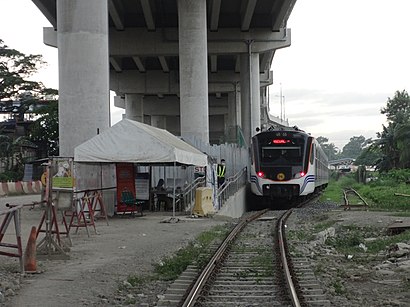
Caloocan Pnr Station Address: Samson Road street in Kalookan City
Places Near Caloocan Pnr Station (Kalookan City)
How to get to popular places in Manila with public transit
Get around Kalookan City by public transit!
Traveling around Kalookan City has never been so easy. See step by step directions as you travel to any attraction, street or major public transit station. View bus and train schedules, arrival times, service alerts and detailed routes on a map, so you know exactly how to get to anywhere in Kalookan City.
When traveling to any destination around Kalookan City use Moovit's Live Directions with Get Off Notifications to know exactly where and how far to walk, how long to wait for your line, and how many stops are left. Moovit will alert you when it's time to get off — no need to constantly re-check whether yours is the next stop.
Wondering how to use public transit in Kalookan City or how to pay for public transit in Kalookan City? Moovit public transit app can help you navigate your way with public transit easily, and at minimum cost. It includes public transit fees, ticket prices, and costs. Looking for a map of Kalookan City public transit lines? Moovit public transit app shows all public transit maps in Kalookan City with all Bus and Train routes and stops on an interactive map.
Manila has 2 transit type(s), including: Bus and Train, operated by several transit agencies, including LRTA, LTFRB, MRTC, PNR, P2P, UV Express and BGC Bus