Directions to J.W. Warner House station (Miami) with public transit
The following transit lines have routes that pass near J.W. Warner House
How to get to J.W. Warner House station by bus?
Click on the bus route to see step by step directions with maps, line arrival times and updated time schedules.
How to get to J.W. Warner House station by train?
Click on the train route to see step by step directions with maps, line arrival times and updated time schedules.
How to get to J.W. Warner House station by ferry?
Click on the ferry route to see step by step directions with maps, line arrival times and updated time schedules.
Bus stops near J.W. Warner House in Miami
- SW 1 ST @ SW 6 AV, 3 min walk,
- S RIVER DR @ W FLAGLER ST, 4 min walk,
- W FLAGLER ST @ NW 6 AV, 5 min walk,
- W FLAGLER ST @ NW 2 AV, 9 min walk,
- SW 7 ST @ SW 5 AV, 9 min walk,
- SW 2 AV @ SW 3 ST, 10 min walk,
- NW NORTH RIVER D @ NW 2 ST, 10 min walk,
Light Rail stations near J.W. Warner House in Miami
- Government Center Station, 12 min walk,
Train stations near J.W. Warner House in Miami
- Government Center, 14 min walk,
- MiamiCentral Station, 15 min walk,
Bus lines to J.W. Warner House station in Miami
- 11, 11- Fiu South Terminal,
- 207, 207 - Via SW 7 St/1 St,
- MIAHAVA, Little Havana Route,
- 208, 208 - Via SW 8 St/Flagler St,
- 21, 21 - Northside Station,
- 8, 8 - Fiu South Terminal,
- MIACOR, Port Of Miami,
- 77, 77 - M. Gardens NW 183 St/7 Av,
What are the closest stations to J.W. Warner House?
The closest stations to J.W. Warner House are:
- SW 1 ST @ SW 6 AV is 162 yards away, 3 min walk.
- S RIVER DR @ W FLAGLER ST is 229 yards away, 4 min walk.
- W FLAGLER ST @ NW 6 AV is 324 yards away, 5 min walk.
- W FLAGLER ST @ NW 2 AV is 677 yards away, 9 min walk.
- SW 7 ST @ SW 5 AV is 682 yards away, 9 min walk.
- SW 2 AV @ SW 3 ST is 749 yards away, 10 min walk.
- NW NORTH RIVER D @ NW 2 ST is 788 yards away, 10 min walk.
- Government Center Station is 961 yards away, 12 min walk.
- Government Center is 1159 yards away, 14 min walk.
- MiamiCentral Station is 1183 yards away, 15 min walk.
Which bus lines stop near J.W. Warner House?
These bus lines stop near J.W. Warner House: 100, 11, 203, 79, MIAHAVA.
Which train line stops near J.W. Warner House?
TRI-RAIL
What’s the nearest light rail station to J.W. Warner House in Miami?
The nearest light rail station to J.W. Warner House in Miami is Government Center Station. It’s a 12 min walk away.
What’s the nearest train station to J.W. Warner House in Miami?
The nearest train station to J.W. Warner House in Miami is Government Center. It’s a 14 min walk away.
What’s the nearest bus station to J.W. Warner House in Miami?
The nearest bus station to J.W. Warner House in Miami is SW 1 ST @ SW 6 AV. It’s a 3 min walk away.
What time is the first light rail to J.W. Warner House in Miami?
The MMO is the first light rail that goes to J.W. Warner House in Miami. It stops nearby at 5:14 AM.
What time is the last light rail to J.W. Warner House in Miami?
The MMI is the last light rail that goes to J.W. Warner House in Miami. It stops nearby at 12:22 AM.
What time is the first subway to J.W. Warner House in Miami?
The 2500 is the first subway that goes to J.W. Warner House in Miami. It stops nearby at 5:19 AM.
What time is the last subway to J.W. Warner House in Miami?
The 2500 is the last subway that goes to J.W. Warner House in Miami. It stops nearby at 12:38 AM.
What time is the first train to J.W. Warner House in Miami?
The TRI-RAIL is the first train that goes to J.W. Warner House in Miami. It stops nearby at 6:00 AM.
What time is the last train to J.W. Warner House in Miami?
The TRI-RAIL is the last train that goes to J.W. Warner House in Miami. It stops nearby at 12:29 AM.
What time is the first bus to J.W. Warner House in Miami?
The 11 is the first bus that goes to J.W. Warner House in Miami. It stops nearby at 3:09 AM.
What time is the last bus to J.W. Warner House in Miami?
The 77 is the last bus that goes to J.W. Warner House in Miami. It stops nearby at 3:52 AM.
See J.W. Warner House, Miami, on the map
Public Transit to J.W. Warner House in Miami
Wondering how to get to J.W. Warner House in Miami, United States? Moovit helps you find the best way to get to J.W. Warner House with step-by-step directions from the nearest public transit station.
Moovit provides free maps and live directions to help you navigate through your city. View schedules, routes, timetables, and find out how long does it take to get to J.W. Warner House in real time.
Looking for the nearest stop or station to J.W. Warner House? Check out this list of stops closest to your destination: SW 1 ST @ SW 6 AV; S RIVER DR @ W FLAGLER ST; W FLAGLER ST @ NW 6 AV; W FLAGLER ST @ NW 2 AV; SW 7 ST @ SW 5 AV; SW 2 AV @ SW 3 ST; NW NORTH RIVER D @ NW 2 ST; Government Center Station; Government Center; MiamiCentral Station.
Bus: 100, 11, 203, 79, MIAHAVA, 207, 208, 21.Train: TRI-RAIL, 2600, TRI-RAIL EXPRESS, TRI-RAIL MIAMICENTRAL.
Want to see if there’s another route that gets you there at an earlier time? Moovit helps you find alternative routes or times. Get directions from and directions to J.W. Warner House easily from the Moovit App or Website.
We make riding to J.W. Warner House easy, which is why over 1.5 million users, including users in Miami, trust Moovit as the best app for public transit. You don’t need to download an individual bus app or train app, Moovit is your all-in-one transit app that helps you find the best bus time or train time available.
For information on prices of bus and train, costs and ride fares to J.W. Warner House, please check the Moovit app.
Use the app to navigate to popular places including to the airport, hospital, stadium, grocery store, mall, coffee shop, school, college, and university.
J.W. Warner House Address: 111 SW 5th Ave street in Miami
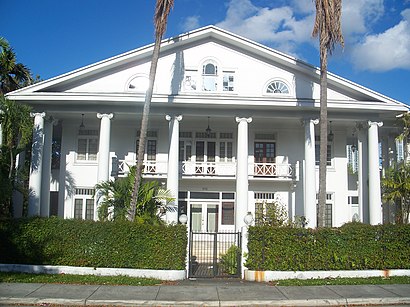
The J. W. Warner House is a historic home in Miami, Florida. It is located at 111 Southwest 5th Avenue. On June 1, 1983, it was added to the U.S. National Register of Historic Places.Wiki
Places Near J.W. Warner House (Miami)
How to get to popular places in Miami with public transit
Get around Miami by public transit!
Traveling around Miami has never been so easy. See step by step directions as you travel to any attraction, street or major public transit station. View bus and train schedules, arrival times, service alerts and detailed routes on a map, so you know exactly how to get to anywhere in Miami.
When traveling to any destination around Miami use Moovit's Live Directions with Get Off Notifications to know exactly where and how far to walk, how long to wait for your line, and how many stops are left. Moovit will alert you when it's time to get off — no need to constantly re-check whether yours is the next stop.
Wondering how to use public transit in Miami or how to pay for public transit in Miami? Moovit public transit app can help you navigate your way with public transit easily, and at minimum cost. It includes public transit fees, ticket prices, and costs. Looking for a map of Miami public transit lines? Moovit public transit app shows all public transit maps in Miami with all Bus, Train, Light Rail and Ferry routes and stops on an interactive map.
Miami has 4 transit type(s), including: Bus, Train, Light Rail and Ferry, operated by several transit agencies, including Miami-Dade Transit, Broward County Transit, Miami Dade Transit-Rail, Palm Tran, Brightline, City of Homestead Trolley, MARTY, Treasure Coast Connector, Sun Trolley , GoLine IRT, Key West Transit, Tri-Rail, Aventura Express Shuttle Bus, Amtrak and Megabus