Directions to New Dorp Lighthouse (Staten Island) with public transportation
The following transit lines have routes that pass near New Dorp Lighthouse
How to get to New Dorp Lighthouse by bus?
Click on the bus route to see step by step directions with maps, line arrival times and updated time schedules.
Subway stations near New Dorp Lighthouse in Staten Island
- New Dorp Station,16 min walk,
Bus stations near New Dorp Lighthouse in Staten Island
- New Dorp La/Mill Rd,28 min walk,
- Brielle Av/Babe Ruth Stadium,47 min walk,
Bus lines to New Dorp Lighthouse in Staten Island
- S76,St George Ferry,
- S54,Eltingville Richmond Av,
What are the closest stations to New Dorp Lighthouse?
The closest stations to New Dorp Lighthouse are:
- New Dorp Station is 1180 yards away, 16 min walk.
- New Dorp La/Mill Rd is 2188 yards away, 28 min walk.
- Brielle Av/Babe Ruth Stadium is 3846 yards away, 47 min walk.
Which bus lines stop near New Dorp Lighthouse?
These bus lines stop near New Dorp Lighthouse: S74, S79-SBS, SIM1C, SIM4C.
What’s the nearest subway station to New Dorp Lighthouse in Staten Island?
The nearest subway station to New Dorp Lighthouse in Staten Island is New Dorp Station. It’s a 16 min walk away.
See New Dorp Lighthouse, Staten Island, on the map
Public Transit to New Dorp Lighthouse in Staten Island
Wondering how to get to New Dorp Lighthouse in Staten Island, United States? Moovit helps you find the best way to get to New Dorp Lighthouse with step-by-step directions from the nearest public transit station.
Moovit provides free maps and live directions to help you navigate through your city. View schedules, routes, timetables, and find out how long does it take to get to New Dorp Lighthouse in real time.
Looking for the nearest stop or station to New Dorp Lighthouse? Check out this list of stops closest to your destination: New Dorp Station; New Dorp La/Mill Rd; Brielle Av/Babe Ruth Stadium.
Bus:S74S79-SBSSIM1CSIM4CS76S54Subway:SIR
Want to see if there’s another route that gets you there at an earlier time? Moovit helps you find alternative routes or times. Get directions from and directions to New Dorp Lighthouse easily from the Moovit App or Website.
We make riding to New Dorp Lighthouse easy, which is why over 1.5 million users, including users in Staten Island, trust Moovit as the best app for public transit. You don’t need to download an individual bus app or train app, Moovit is your all-in-one transit app that helps you find the best bus time or train time available.
For information on prices of bus, light rail, subway and train, costs and ride fares to New Dorp Lighthouse, please check the Moovit app.
Use the app to navigate to popular places including to the airport, hospital, stadium, grocery store, mall, coffee shop, school, college, and university.
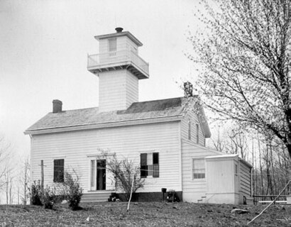
New Dorp Lighthouse Address: Boyle Street street in Staten Island
Attractions near New Dorp Lighthouse
200 Beacon Avenue,Boyle Beacon,317 Walden Ave,199 Walden Ave,Forest Ave (forest prospect),Central Ave at Prospect,Forest Prospect Ave,Central Ave Prospect Ave,Prospect and Central Ave,Prospect Ave Central,978 Walden Ave,Central Ave,Central Ave Glenwood,Cross Central,Cross Ave crossing Central Ave,Central Ave @ Cross,Sycamore Ave,Prospect Ave Sycamore Ave,Sycamore Ave (prospect and sycamore),Atlantic Ave (atlantic avenue & landscape)How to get to popular attractions in Staten Island with public transit
Long Island, NY, Huntington Station, Ny,The Kunjip, Manhattan,Stout, Manhattan,Nassau Community College, East Garden City, Ny,Fette Sau,Atlantic City, NJ, Atlantic City, Nj,MTA Subway - Coney Island / Stillwell Ave (D / F/N / Q),Gramercy Tavern, Manhattan,Culture Espresso, Manhattan,Ritz Bar & Lounge, Manhattan,Time Life, Manhattan,Starbucks, East Brunswick, Nj,Café Habana, Manhattan,Nan Xiang Xiao Long Bao, Queens,Avenue, Manhattan,NJT - New Brunswick Station (NEC), New Brunswick, Nj,MTA Subway - Broadway (N/W), Queens,Kew Gardens, NY, Queens,Ulysses Folk House, Manhattan,New Jersey, Nutley, NjGet around Staten Island by public transit!
Traveling around Staten Island has never been so easy. See step by step directions as you travel to any attraction, street or major public transit station. View bus and train schedules, arrival times, service alerts and detailed routes on a map, so you know exactly how to get to anywhere in Staten Island.
When traveling to any destination around Staten Island use Moovit's Live Directions with Get Off Notifications to know exactly where and how far to walk, how long to wait for your line, and how many stops are left. Moovit will alert you when it's time to get off — no need to constantly re-check whether yours is the next stop.
Wondering how to use public transit in Staten Island or how to pay for public transit in Staten Island? Moovit public transit app can help you navigate your way with public transit easily, and at minimum cost. It includes public transit fees, ticket prices, and costs. Looking for a map of Staten Island public transit lines? Moovit public transit app shows all public transit maps in Staten Island with all bus, light rail, subway or train routes and stops on an interactive map.
Staten Island has 4 transit type(s), including: bus, light rail, subway or train, operated by several transit agencies, including MTA Subway, Metro-North Railroad, LIRR, PATH, Shore Line East, MTA Bus Company, MTA New York City Transit - Express routes, MTA Bus, NJ Transit, NYC Ferry, NICE bus, Bee-Line Bus, NJ Transit Rail, NJ Transit Rail and Norwalk Transit District