Directions to Orthotics & Prosthetics Laboratories, Inc. (Boston) with public transportation
The following transit lines have routes that pass near Orthotics & Prosthetics Laboratories, Inc.
 Bus: G1, B4, T4, T2, T21.
- Train: LAKE SHORE LIMITED, VERMONTER, AMTRAK HARTFORD LINE, NORTHEAST REGIONAL, VALLEY FLYER.
How to get to Orthotics & Prosthetics Laboratories, Inc. by bus?
Click on the bus route to see step by step directions with maps, line arrival times and updated time schedules.
From South High Community School, Worcester
198 minFrom Polar Park, Worcester
102 minFrom Worcester, MA, Worcester
101 minFrom Foxwoods, Worcester
130 minFrom Registry Of Motor Vehicles (Rmv) Branch Office, Worcester
105 minFrom Palladium, Worcester
106 minFrom Walmart Supercenter, Worcester
160 minFrom Dcu Center, Worcester
103 min
How to get to Orthotics & Prosthetics Laboratories, Inc. by train?
Click on the train route to see step by step directions with maps, line arrival times and updated time schedules.
Bus stops near Orthotics & Prosthetics Laboratories, Inc. in Boston
Train station near Orthotics & Prosthetics Laboratories, Inc. in Boston
- Springfield, 10 min walk,VIEW
Bus lines to Orthotics & Prosthetics Laboratories, Inc. in Boston
What are the closest stations to Orthotics & Prosthetics Laboratories, Inc.?
The closest stations to Orthotics & Prosthetics Laboratories, Inc. are:
- Wason / Fisk is 12 yards away, 1 min walk.
- Plainfield / Clayton is 15 yards away, 1 min walk.
- Main / Holland is 377 yards away, 5 min walk.
- Plainfield / Clayton (Opposite) is 381 yards away, 5 min walk.
- 3300 Main Street is 506 yards away, 6 min walk.
- Springfield is 807 yards away, 10 min walk.
Which bus line stops near Orthotics & Prosthetics Laboratories, Inc.?
G1 (Chicopee Big Y)
Which train lines stop near Orthotics & Prosthetics Laboratories, Inc.?
These train lines stop near Orthotics & Prosthetics Laboratories, Inc.: LAKE SHORE LIMITED, VERMONTER.
What’s the nearest train station to Orthotics & Prosthetics Laboratories, Inc. in Boston?
The nearest train station to Orthotics & Prosthetics Laboratories, Inc. in Boston is Springfield. It’s a 10 min walk away.
What’s the nearest bus station to Orthotics & Prosthetics Laboratories, Inc. in Boston?
The nearest bus stations to Orthotics & Prosthetics Laboratories, Inc. in Boston are Wason / Fisk and Plainfield / Clayton. The closest one is a 1 min walk away.
What time is the first train to Orthotics & Prosthetics Laboratories, Inc. in Boston?
The NORTHEAST REGIONAL is the first train that goes to Orthotics & Prosthetics Laboratories, Inc. in Boston. It stops nearby at 4:10 AM.
What time is the last train to Orthotics & Prosthetics Laboratories, Inc. in Boston?
The LAKE SHORE LIMITED is the last train that goes to Orthotics & Prosthetics Laboratories, Inc. in Boston. It stops nearby at 6:04 PM.
What time is the first bus to Orthotics & Prosthetics Laboratories, Inc. in Boston?
The B4 is the first bus that goes to Orthotics & Prosthetics Laboratories, Inc. in Boston. It stops nearby at 5:55 AM.
What time is the last bus to Orthotics & Prosthetics Laboratories, Inc. in Boston?
The G1 is the last bus that goes to Orthotics & Prosthetics Laboratories, Inc. in Boston. It stops nearby at 9:56 PM.
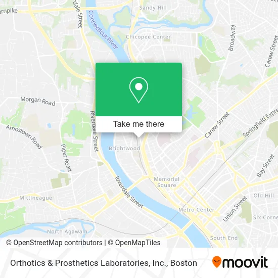
See Orthotics & Prosthetics Laboratories, Inc., Boston, on the map
Public Transit to Orthotics & Prosthetics Laboratories, Inc. in Boston
Wondering how to get to Orthotics & Prosthetics Laboratories, Inc. in Boston? Moovit helps you find the best way to get to Orthotics & Prosthetics Laboratories, Inc. with step-by-step directions from the nearest public transit station.
Moovit provides free maps and live directions to help you navigate through your city. View schedules, routes, timetables, and find out how long does it take to get to Orthotics & Prosthetics Laboratories, Inc. in real time.
Looking for the nearest stop or station to Orthotics & Prosthetics Laboratories, Inc.? Check out this list of stops closest to your destination: Wason / Fisk; Plainfield / Clayton; Main / Holland; Plainfield / Clayton (Opposite); 3300 Main Street; Springfield.
Bus: G1, B4, T4, T2, T21, T1, T3, T5, T92.Train: LAKE SHORE LIMITED, VERMONTER, AMTRAK HARTFORD LINE, NORTHEAST REGIONAL, VALLEY FLYER.
Want to see if there’s another route that gets you there at an earlier time? Moovit helps you find alternative routes or times. Get directions from and directions to Orthotics & Prosthetics Laboratories, Inc. easily from the Moovit App or Website.
We make riding to Orthotics & Prosthetics Laboratories, Inc. easy, which is why over 1.7 million users, including users in Boston, trust Moovit as the best app for public transit. You don’t need to download an individual bus app or train app, Moovit is your all-in-one transit app that helps you find the best bus time or train time available.
For information on prices of bus and train, costs and ride fares to Orthotics & Prosthetics Laboratories, Inc., please check the Moovit app.
Use the app to navigate to popular places including to the airport, hospital, stadium, grocery store, mall, coffee shop, school, college, and university.
Orthotics & Prosthetics Laboratories, Inc. Address: 300 Birnie Ave street in Boston
- Jennie Garver MD,
- Dr John R Corsetti, MD,
- Auto Repair Steering & Suspension Auto Repair,
- Braden Gregory MD,
- Ati Physical Therapy,
- J Stephen Brecht MD,
- James Hession MD,
- Elk Industries,
- Extra Space Storage,
- CHD,
- Early Intervention,
- CHD Institute for Dynamic Living,
- Baycare Health Partners,
- Baltazar Contractors,
- Holyoke Card & Paper Co.,
- Baystate Health Tolosky Center,
- Neha Malhotra, MD,
- Kidney Care & Transplant,
- Steinberg Gerald MD,
- Honeyman David
Places Near Orthotics & Prosthetics Laboratories, Inc. (Boston)
- Castle Island, Boston,
- Boston Common, Boston,
- Quincy Market, Boston,
- Seaport District, Boston,
- Massachusetts General Hospital, Boston,
- House Of Blues, Boston,
- Leader Bank Pavilion (Leader Bank Pavillion), Boston,
- Faneuil Hall, Boston,
- Museum Of Science, Boston,
- Boston Children's Hospital, Boston,
- Mgm Music Hall, Boston,
- Wang Theater, Boston,
- Boston Medical Center, Boston,
- Boston Convention & Exhibition Center, Boston,
- Isabella Stewart Gardner Museum, Boston,
- Td Garden, Boston,
- Prudential Center, Boston,
- Wilbur Theatre, Boston,
- North End, Boston,
- Cheers, Boston
How to get to popular places in Boston with public transit
Get around Boston by public transit!
Traveling around Boston has never been so easy. See step by step directions as you travel to any attraction, street or major public transit station. View bus and train schedules, arrival times, service alerts and detailed routes on a map, so you know exactly how to get to anywhere in Boston.
When traveling to any destination around Boston use Moovit's Live Directions with Get Off Notifications to know exactly where and how far to walk, how long to wait for your line, and how many stops are left. Moovit will alert you when it's time to get off — no need to constantly re-check whether yours is the next stop.
Wondering how to use public transit in Boston or how to pay for public transit in Boston? Moovit public transit app can help you navigate your way with public transit easily, and at minimum cost. It includes public transit fees, ticket prices, and costs. Looking for a map of Boston public transit lines? Moovit public transit app shows all public transit maps in Boston with all Bus, Train, Subway and Ferry routes and stops on an interactive map.
Boston has 4 transit type(s), including: Bus, Train, Subway and Ferry, operated by several transit agencies, including MBTA, Southeastern Regional Transit Authority, MetroWest Regional Transit Authority, Rhode Island Public Transit Authority, WRTA, Lowell Regional Transit Authority, Merrimack Valley Transit, Montachusett Regional Transit Authority, Cape Cod Regional Transit Authority, Brockton Area Transit Authority, Martha's Vineyard Transit Authority, the WAVE - Nantucket Regional Transit Authority, GATRA, Cape Ann Transportation Authority and Massport