Directions to Pont D'Engordany (Les Escaldes) with public transportation
The following transit lines have routes that pass near Pont D'Engordany
How to get to Pont D'Engordany by bus?
Click on the bus route to see step by step directions with maps, line arrival times and updated time schedules.
Bus stops near Pont D'Engordany in Les Escaldes
- La Drecera, 5 min walk,
- Plaça Sta. Anna, 5 min walk,
- Arnaldeta De Caboet, 6 min walk,
Bus lines to Pont D'Engordany in Les Escaldes
- LC, Andorra La Vella,
- BN1, Andorra La Vella – Ordino,
- L1, Escaldes-Engordany,
- BN2, Andorra La Vella – Canillo,
- L2, Encamp,
- L3, Andorra La Vella,
- L4, Pas De La Casa,
- BN3, Escaldes-Engordany – Sant Julià De Lòria,
What are the closest stations to Pont D'Engordany?
The closest stations to Pont D'Engordany are:
- La Drecera is 373 meters away, 5 min walk.
- Plaça Sta. Anna is 383 meters away, 5 min walk.
- Arnaldeta De Caboet is 435 meters away, 6 min walk.
Which bus lines stop near Pont D'Engordany?
These bus lines stop near Pont D'Engordany: L1, L4, L5.
What’s the nearest bus stop to Pont D'Engordany in Les Escaldes?
The nearest bus stops to Pont D'Engordany in Les Escaldes are La Drecera and Plaça Sta. Anna. The closest one is a 5 min walk away.
What time is the first bus to Pont D'Engordany in Les Escaldes?
The BN2 is the first bus that goes to Pont D'Engordany in Les Escaldes. It stops nearby at 3:09 AM.
What time is the last bus to Pont D'Engordany in Les Escaldes?
The L1 is the last bus that goes to Pont D'Engordany in Les Escaldes. It stops nearby at 10:56 PM.
See Pont D'Engordany, Les Escaldes, on the map
Public Transit to Pont D'Engordany in Les Escaldes
Wondering how to get to Pont D'Engordany in Les Escaldes, Andorra? Moovit helps you find the best way to get to Pont D'Engordany with step-by-step directions from the nearest public transit station.
Moovit provides free maps and live directions to help you navigate through your city. View schedules, routes, timetables, and find out how long does it take to get to Pont D'Engordany in real time.
Looking for the nearest stop or station to Pont D'Engordany? Check out this list of stops closest to your destination: La Drecera; Plaça Sta. Anna; Arnaldeta De Caboet.
Bus: L1, L4, L5, LC, BN1, BN2, L2, L3, BN3.
Want to see if there’s another route that gets you there at an earlier time? Moovit helps you find alternative routes or times. Get directions from and directions to Pont D'Engordany easily from the Moovit App or Website.
We make riding to Pont D'Engordany easy, which is why over 1.5 million users, including users in Les Escaldes, trust Moovit as the best app for public transit. You don’t need to download an individual bus app or train app, Moovit is your all-in-one transit app that helps you find the best bus time or train time available.
For information on prices of bus, costs and ride fares to Pont D'Engordany, please check the Moovit app.
Use the app to navigate to popular places including to the airport, hospital, stadium, grocery store, mall, coffee shop, school, college, and university.
Pont D'Engordany Address: Carrer d'Engordany street in Les Escaldes
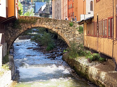
Pont d'Engordany is a bridge located in Escaldes-Engordany Parish, Andorra. It is a heritage property registered in the Cultural Heritage of Andorra. It was built in 1785.Wiki
Attractions near Pont D'Engordany
1951,Llenceria Fanny,Hotel Siracusa,Serra Do Gerês,Martin Imatge,Tot a Punt,Yes Events,Pyrenees Luxe,MANGO Escaldes Illa Ca,Museu Carmen Thyssen,Wi-Fi Ar,Dandybike,Supermercat el Gautxo,Centre d'interpretació de l'Aigua i del Madriu CIAM,Andorra-la-Vella,Alberg Rossell,Alberg Els Andes,Artalroc Sala de Exposiciones del Gobierno,Sant Pere Martir,Sant Pere MàrtirHow to get to popular attractions in Les Escaldes with public transit
Ordino, Ordino,Funicamp, Encamp,Centre Prestige Automobils,Andorra döner kebab, Andorra La Vella,Hotel Cristina, El Pas De La Casa,Cerveseria Era Bauro, Andorra La Vella,Encamp, Encamp,Pans & Company, Sant Julià De Lòria,Govern D'Andorra, Andorra La Vella,Hotel Ransol, Canillo,Pal,Plaça Del Poble, Andorra La Vella,Universitat D'Andorra, Sant Julià De Lòria,Borda L'Era del Rossell, Meritxell,Les Escaldes, Les Escaldes,El Raco Mexica, Andorra La Vella,pub son son karaoke, Andorra La Vella,Plaça Carlemany, Canillo,Caldea-Inuu, Les Escaldes,Husa Patagonia Hotel Arinsal, ArinsalGet around Andorra la Vella by public transit!
Traveling around Andorra la Vella has never been so easy. See step by step directions as you travel to any attraction, street or major public transit station. View bus and train schedules, arrival times, service alerts and detailed routes on a map, so you know exactly how to get to anywhere in Andorra la Vella.
When traveling to any destination around Andorra la Vella use Moovit's Live Directions with Get Off Notifications to know exactly where and how far to walk, how long to wait for your line, and how many stops are left. Moovit will alert you when it's time to get off — no need to constantly re-check whether yours is the next stop.
Wondering how to use public transit in Andorra la Vella or how to pay for public transit in Andorra la Vella? Moovit public transit app can help you navigate your way with public transit easily, and at minimum cost. It includes public transit fees, ticket prices, and costs. Looking for a map of Andorra la Vella public transit lines? Moovit public transit app shows all public transit maps in Andorra la Vella with all bus routes and stops on an interactive map.
Andorra la Vella has 1 transit type(s), including: bus, operated by several transit agencies, including Cooperativa Interurbana Andorrana, Grup Montmantell