Directions to Pont du Garigliano station (Paris) with public transit
The following transit lines have routes that pass near Pont du Garigliano
How to get to Pont du Garigliano station by bus?
Click on the bus route to see step by step directions with maps, line arrival times and updated time schedules.
How to get to Pont du Garigliano station by metro?
Click on the metro route to see step by step directions with maps, line arrival times and updated time schedules.
Bus stops near Pont du Garigliano in Paris
- Pont du Garigliano, 1 min walk,
- Pont du Garigliano - Hôpital Européen Georges Pompidou, 2 min walk,
- Versailles - Exelmans, 3 min walk,
- Hôpital Européen Georges Pompidou, 4 min walk,
Metro stations near Pont du Garigliano in Paris
- Chardon Lagache, 9 min walk,
- Balard, 10 min walk,
RER station near Pont du Garigliano in Paris
- Pont du Garigliano - Hôpital Européen G. Pompidou, 10 min walk,
Light Rail stations near Pont du Garigliano in Paris
- Suzanne Lenglen, 13 min walk,
Bus lines to Pont du Garigliano station in Paris
- 42, Gare Saint-Lazare,
- 88, Montsouris -Tombe Issoire,
- N160, Gare Montparnasse,
- 3754, Porte de Saint-Cloud - Murat,
- PC, Pont du Garigliano - Hôpital Européen Georges Pompidou,
- N12, Porte de Saint-Cloud,
- N61, Gare Montparnasse,
- 30, Pigalle - Hôpital Européen Georges Pompidou,
- 169, Pont De Sèvres - Hôpital Européen Georges Pompidou,
- 22, Gare Saint-Lazare,
- 72, Gare de Lyon - Maison de la Ratp,
What are the closest stations to Pont du Garigliano?
The closest stations to Pont du Garigliano are:
- Pont du Garigliano is 35 meters away, 1 min walk.
- Pont du Garigliano - Hôpital Européen Georges Pompidou is 96 meters away, 2 min walk.
- Versailles - Exelmans is 159 meters away, 3 min walk.
- Hôpital Européen Georges Pompidou is 285 meters away, 4 min walk.
- Chardon Lagache is 663 meters away, 9 min walk.
- Pont du Garigliano - Hôpital Européen G. Pompidou is 708 meters away, 10 min walk.
- Balard is 708 meters away, 10 min walk.
- Suzanne Lenglen is 987 meters away, 13 min walk.
Which RER line stops near Pont du Garigliano?
C (Massy - Palaiseau/ Dourdan - La Forêt/ Saint-Martin-d'Étampes)
Which metro line stops near Pont du Garigliano?
8 (Pointe du Lac)
Which bus lines stop near Pont du Garigliano?
These bus lines stop near Pont du Garigliano: 39, 42, 72, 88.
Which light rail line stops near Pont du Garigliano?
T3A (Pont du Garigliano)
What’s the nearest light rail station to Pont du Garigliano in Paris?
The nearest light rail station to Pont du Garigliano in Paris is Suzanne Lenglen. It’s a 13 min walk away.
What’s the nearest metro station to Pont du Garigliano in Paris?
The nearest metro station to Pont du Garigliano in Paris is Chardon Lagache. It’s a 9 min walk away.
What’s the nearest bus station to Pont du Garigliano in Paris?
The nearest bus station to Pont du Garigliano in Paris is Pont du Garigliano. It’s a 1 min walk away.
What’s the nearest RER station to Pont du Garigliano in Paris?
The nearest RER station to Pont du Garigliano in Paris is Pont du Garigliano - Hôpital Européen G. Pompidou. It’s a 10 min walk away.
What time is the first light rail to Pont du Garigliano in Paris?
The T2 is the first light rail that goes to Pont du Garigliano in Paris. It stops nearby at 5:10 AM.
What time is the last light rail to Pont du Garigliano in Paris?
The T3A is the last light rail that goes to Pont du Garigliano in Paris. It stops nearby at 1:47 AM.
What time is the first metro to Pont du Garigliano in Paris?
The 8 is the first metro that goes to Pont du Garigliano in Paris. It stops nearby at 5:17 AM.
What time is the last metro to Pont du Garigliano in Paris?
The 8 is the last metro that goes to Pont du Garigliano in Paris. It stops nearby at 1:15 AM.
What time is the first bus to Pont du Garigliano in Paris?
The N12 is the first bus that goes to Pont du Garigliano in Paris. It stops nearby at 3:12 AM.
What time is the last bus to Pont du Garigliano in Paris?
The N160 is the last bus that goes to Pont du Garigliano in Paris. It stops nearby at 3:49 AM.
What time is the first RER to Pont du Garigliano in Paris?
The C is the first RER that goes to Pont du Garigliano in Paris. It stops nearby at 5:17 AM.
What time is the last RER to Pont du Garigliano in Paris?
The C is the last RER that goes to Pont du Garigliano in Paris. It stops nearby at 11:14 PM.
See Pont du Garigliano, Paris, on the map
Public Transit to Pont du Garigliano in Paris
How to get to Pont du Garigliano in Paris, France?
It’s easy with Moovit. Type in your street address and Moovit’s route finder will locate the fastest way to get you there! Not sure where to get off on the street? Download the Moovit App to find live directions (including where to get off on Pont du Garigliano), see timetables and get the estimated arrival times for your favorite RER, metro, bus or light rail lines.
Looking for the nearest stop or station to Pont du Garigliano? Check out this list of closest stops available to your destination: Pont du Garigliano; Pont du Garigliano - Hôpital Européen Georges Pompidou; Versailles - Exelmans; Hôpital Européen Georges Pompidou; Chardon Lagache; Pont du Garigliano - Hôpital Européen G. Pompidou; Balard; Suzanne Lenglen.
RER: C, T3A.Metro: 8, 10.Bus: 39, 42, 72, 88, N160, 3754, PC, N12, N61.Light Rail: T3A.
Download the Moovit App to see the current schedule and routes available for Paris. No need to install a special bus app to check the bus time or a train app to get train time. Moovit is the only all-in-one transit app that helps you get where you need to go.
We make riding on public transit to Pont du Garigliano easy, which is why over 1.5 million users, including users in Paris trust Moovit as the best app for public transit.
Use the app to navigate to popular places including to the airport, hospital, stadium, grocery store, mall, coffee shop, school, college, and university.
Location: Paris
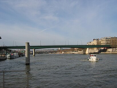
The Pont du Garigliano is a bridge across the Seine in Paris.Wiki
Streets near Pont du Garigliano, Paris
Get around Paris by public transit!
Traveling around Paris has never been so easy. See step by step directions as you travel to any attraction, street or major public transit station. View bus and train schedules, arrival times, service alerts and detailed routes on a map, so you know exactly how to get to anywhere in Paris.
When traveling to any destination around Paris use Moovit's Live Directions with Get Off Notifications to know exactly where and how far to walk, how long to wait for your line, and how many stops are left. Moovit will alert you when it's time to get off — no need to constantly re-check whether yours is the next stop.
Wondering how to use public transit in Paris or how to pay for public transit in Paris? Moovit public transit app can help you navigate your way with public transit easily, and at minimum cost. It includes public transit fees, ticket prices, and costs. Looking for a map of Paris public transit lines? Moovit public transit app shows all public transit maps in Paris with all Bus, Train, Metro, Light Rail, RER and Funicular routes and stops on an interactive map.
Paris has 6 transit type(s), including: Bus, Train, Metro, Light Rail, RER and Funicular, operated by several transit agencies, including SAVAC, Apolo 7, Seine et Marne Express, Autobus du Fort, Sit'bus, RATP, Train Bus de remplacement, RER Bus de remplacement, Keolis Mobilité Roissy, Seine-Saint-Denis, Réseau Linéad | Lignes urbaines, Train, RER, TER and Tramway