R. Afonso Celso, 1337 stop - Thursday schedule
| Line | Direction | Time |
|---|---|---|
| 577T-10 | Metrô Ana Rosa | 4:56 AM |
| 5164-21 | Pq. Ibirapuera | 5:00 AM |
| 5123-10 | Hosp. São Paulo | 5:03 AM |
| 4718-10 | Metrô Sta. Cruz | 5:10 AM |
| 5164-10 | Pq. Ibirapuera | 5:11 AM |
| 5123-10 | Hosp. São Paulo | 5:19 AM |
| 5164-21 | Pq. Ibirapuera | 5:21 AM |
| 502J-10 | Metrô Sta. Cruz | 5:24 AM |
| 4716-10 | Metrô Sta. Cruz | 5:24 AM |
| 5164-10 | Pq. Ibirapuera | 5:28 AM |
| 577T-10 | Metrô Ana Rosa | 5:28 AM |
| 502J-10 | Metrô Sta. Cruz | 5:34 AM |
| 5123-10 | Hosp. São Paulo | 5:35 AM |
| 4716-10 | Metrô Sta. Cruz | 5:40 AM |
| 5164-21 | Pq. Ibirapuera | 5:42 AM |
| 4718-10 | Metrô Sta. Cruz | 5:43 AM |
| 5164-10 | Pq. Ibirapuera | 5:44 AM |
| 502J-10 | Metrô Sta. Cruz | 5:45 AM |
| 5123-10 | Hosp. São Paulo | 5:46 AM |
| 5123-10 | Hosp. São Paulo | 5:52 AM |
| 4716-10 | Metrô Sta. Cruz | 5:52 AM |
| 502J-10 | Metrô Sta. Cruz | 5:56 AM |
| 5123-10 | Hosp. São Paulo | 5:58 AM |
| 5164-10 | Pq. Ibirapuera | 5:59 AM |
| 577T-10 | Metrô Ana Rosa | 6:01 AM |
Directions to R. Afonso Celso, 1337 stop (Saúde) with public transit
The following transit lines have routes that pass near R. Afonso Celso, 1337
 Bus: 475R-10, 502J-10, 5103-10, 5123-10, 5164-21.
- Metro: LINHA 1, LINHA 5, LINHA 2.
How to get to R. Afonso Celso, 1337 stop by bus?
Click on the bus route to see step by step directions with maps, line arrival times and updated time schedules.
How to get to R. Afonso Celso, 1337 stop by metro?
Click on the metro route to see step by step directions with maps, line arrival times and updated time schedules.
Bus stops near R. Afonso Celso, 1337 stop in Saúde
- R. Afonso Celso, 1461, 2 min walk,
- R. Luís Gois, 635, 3 min walk,
- R. Domingos de Morais, 3015, 4 min walk,
- R. Domingos de Morais, 3088, 4 min walk,
- Rua Loefgreen, 1057 - Metrô Santa Cruz, 7 min walk,
Metro stations near R. Afonso Celso, 1337 station in Saúde
- Chácara Klabin, 5 min walk,
- Vila Mariana, 9 min walk,
Bus lines to R. Afonso Celso, 1337 stop in Saúde
- 4718-10, Metrô Sta. Cruz,
- 4716-10, Metrô Tamanduateí,
- 574A-10, Americanópolis - Largo Cambuci,
- 574A-21, Americanópolis - Metrô Vila Mariana,
- N604-11, Metrô Jabaquara - Terminal Parque Dom Pedro Ii,
- 875A-10, Aeroporto - Perdizes,
- 5106-10, Mar Paulista - Largo São Francisco,
- 5290-10, Domv. Domadema - Terminal Parque Dom Pedro Ii,
- 5791-10, Eldorado - Metrô Vergueiro,
- 475R-10, Jardim São Savério - Terminal Parque Dom Pedro Ii,
- 502J-10, Estação Autódromo - Metrô Santa Cruz,
- 577T-10, Jardim Miriam - Metrô Ana Rosa,
- 5123-10, Jardim Miriam - Hospital São Paulo,
- 5164-10, Vila Santa Catarina - Parque Ibirapuera (Circular),
- 5164-21, Cidade Leonor - Parque Ibirapuera (Circular),
- 6338-10, Jardim Miriam - Parque Ibirapuera (Circular),
- 476A-10, Term. Sto. Amaro,
- N505-11, Term. Pinheiros,
- 5103-10, Moema,
What are the closest stations to R. Afonso Celso, 1337?
The closest stations to R. Afonso Celso, 1337 are:
- R. Afonso Celso, 1461 stop is 126 meters away, 2 min walk.
- R. Luís Gois, 635 stop is 220 meters away, 3 min walk.
- R. Domingos de Morais, 3015 stop is 252 meters away, 4 min walk.
- R. Domingos de Morais, 3088 stop is 305 meters away, 4 min walk.
- Chácara Klabin station is 341 meters away, 5 min walk.
- Rua Loefgreen, 1057 - Metrô Santa Cruz stop is 531 meters away, 7 min walk.
- Vila Mariana station is 650 meters away, 9 min walk.
Which bus lines stop near R. Afonso Celso, 1337?
These bus lines stop near R. Afonso Celso, 1337: 475R-10, 502J-10, 5103-10, 5123-10, 5164-21, 5290-10, 574A-10, 875A-10.
Which metro lines stop near R. Afonso Celso, 1337?
These metro lines stop near R. Afonso Celso, 1337: LINHA 1, LINHA 5.
What’s the nearest metro station to R. Afonso Celso, 1337 in Saúde?
The nearest metro station to R. Afonso Celso, 1337 in Saúde is Chácara Klabin. It’s a 5 min walk away.
What’s the nearest bus station to R. Afonso Celso, 1337 in Saúde?
The nearest bus station to R. Afonso Celso, 1337 in Saúde is R. Afonso Celso, 1461. It’s a 2 min walk away.
What time is the first metro to R. Afonso Celso, 1337 in Saúde?
The LINHA 5 is the first metro that goes to R. Afonso Celso, 1337 in Saúde. It stops nearby at 4:40 AM.
What time is the last metro to R. Afonso Celso, 1337 in Saúde?
The LINHA 1 is the last metro that goes to R. Afonso Celso, 1337 in Saúde. It stops nearby at 12:35 AM.
What time is the first bus to R. Afonso Celso, 1337 in Saúde?
The N505-11 is the first bus that goes to R. Afonso Celso, 1337 in Saúde. It stops nearby at 3:16 AM.
What time is the last bus to R. Afonso Celso, 1337 in Saúde?
The N604-11 is the last bus that goes to R. Afonso Celso, 1337 in Saúde. It stops nearby at 2:58 AM.
R. Afonso Celso, 1337 station
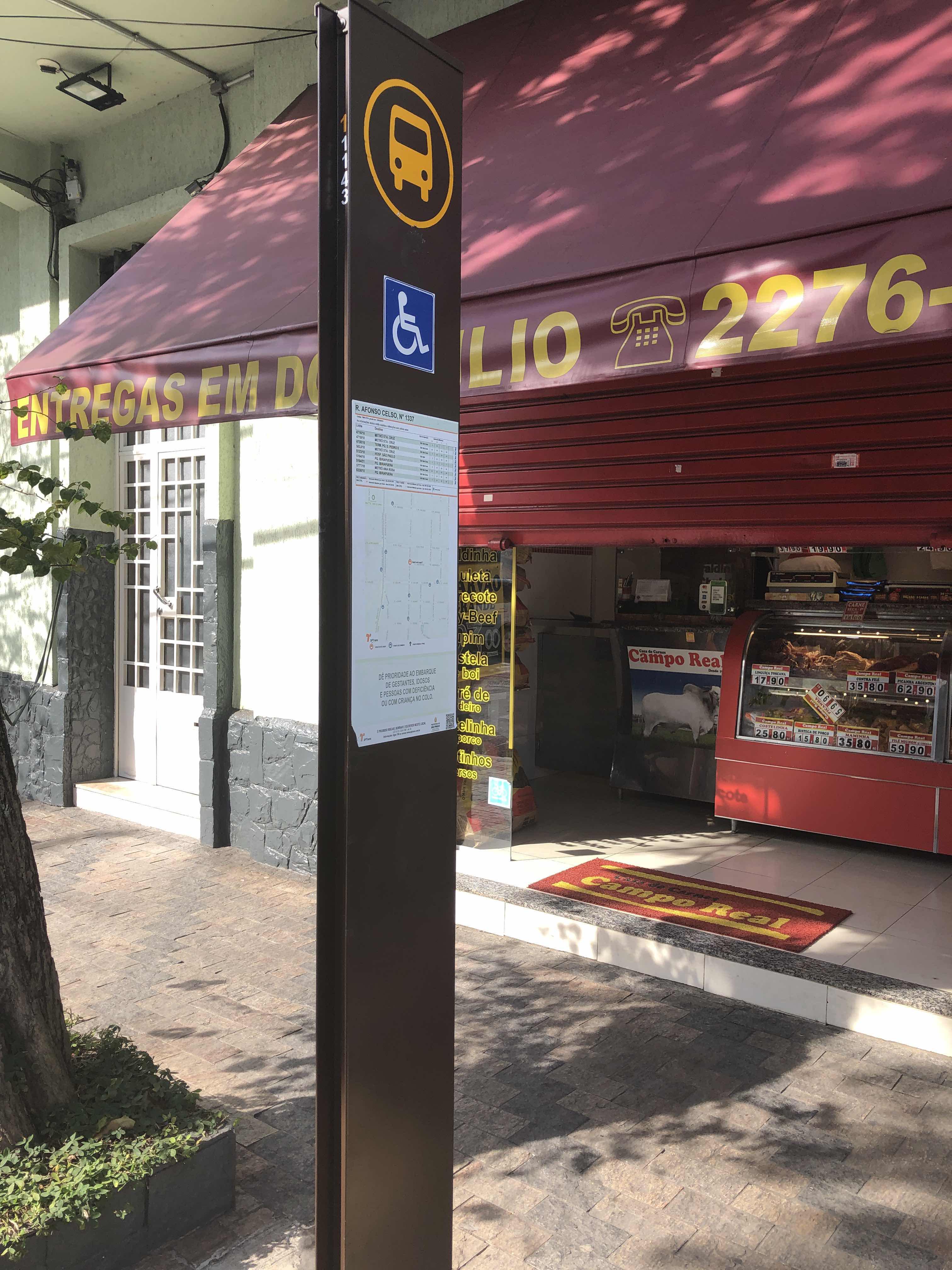 Taken by ivan t.
See R. Afonso Celso, 1337 stop, Saúde, on the map
Public transit to R. Afonso Celso, 1337 stop in Saúde
Looking for directions to R. Afonso Celso, 1337 in Saúde, Brazil?
Download the Moovit App to find the current schedule and step-by-step directions for Bus or Metro routes that pass through R. Afonso Celso, 1337.
Looking for the nearest stops closest to R. Afonso Celso, 1337 ? Check out this list of closest stops to your destination: R. Afonso Celso; R. Luís Gois; R. Domingos de Morais; R. Domingos de Morais; Chácara Klabin; Rua Loefgreen; Vila Mariana.
Bus: 475R-10, 502J-10, 5103-10, 5123-10, 5164-21, 5290-10, 574A-10, 875A-10, 4718-10, 4716-10, 574A-21, N604-11, 5106-10, 577T-10, 5164-10.Metro: LINHA 1, LINHA 5, LINHA 2.
We make riding on public transit to R. Afonso Celso, 1337 easy, which is why over 1.7 billion users, including users in Saúde trust Moovit as the best app for public transit.
Use the app to navigate to popular places including to the airport, hospital, stadium, grocery store, mall, coffee shop, school, college, and university.
The first line to this stop is 577T-10, at 4:56 AM, and the last line is 502J-10 at 1:02 AM.
1354 Rua Afonso Celso, São Paulo, Brazil
This stop serves SPTrans’s lines
- R. Afonso Celso, 1461,
- R. Luís Gois, 635,
- R. Domingos de Morais, 3015,
- R. Domingos de Morais, 3088,
- Rua Loefgreen, 1057 - Metrô Santa Cruz
Bus stops near R. Afonso Celso, 1337 stop
- Chácara Klabin,
- Vila Mariana
Metro stations near R. Afonso Celso, 1337 station
- Avenida Brigadeiro Faria Lima 2528,
- Avenida Antonelo da Messina, 650,
- Guapituba,
- Imperatriz Leopoldina,
- Parada Anchieta (Piraporinha),
- Terminal Metro Belém Norte,
- Terminal Barra Funda Lado Norte,
- Av. Jorn. Paulo Zing, 1153,
- R. Recanto do Sol, 40,
- R. Da. Ana Flora Pinheiro de Souza, 76,
- R. Werner Von Siemens, 111,
- Av. Hebe Camargo - Antônio F. de Castilho 8,
- Av. Manuel Bandeira, 360 - Vila Leopoldina, São Paulo,
- João Cachoeira B/C,
- Terminal Água Espraiada,
- Av. Rodrigues Montemor, 297,
- Jundiaí,
- Rodovia Raposo Tavares (Km 16,4/São Paulo),
- Parada Jk,
- Ponto Final/Inicial Jardim Muriano
Popular public transit stations in Saúde
Get around Saúde by public transit!
Traveling around Saúde has never been so easy. See step by step directions as you travel to any attraction, street or major public transit station. View bus and train schedules, arrival times, service alerts and detailed routes on a map, so you know exactly how to get to anywhere in Saúde.
When traveling to any destination around Saúde use Moovit's Live Directions with Get Off Notifications to know exactly where and how far to walk, how long to wait for your line, and how many stops are left. Moovit will alert you when it's time to get off — no need to constantly re-check whether yours is the next stop.
Wondering how to use public transit in Saúde or how to pay for public transit in Saúde? Moovit public transit app can help you navigate your way with public transit easily, and at minimum cost. It includes public transit fees, ticket prices, and costs. Looking for a map of Saúde public transit lines? Moovit public transit app shows all public transit maps in Saúde with all Bus, Train, Metro, Light Rail, Ferry, Gondola, Cable Car and Funicular routes and stops on an interactive map.
Sao Paulo Region has 8 transit type(s), including: Bus, Train, Metro, Light Rail, Ferry, Gondola, Cable Car and Funicular, operated by several transit agencies, including SPTrans, CPTM, ViaMobilidade, Aquático SP, SPTRANS, EMTU, ViaQuatro, Auto Ônibus Moratense, GRU Airport (Aeroporto de Guarulhos), Auto Viação Urubupungá (Cajamar), Viação Cometa, Auto Viação Urubupungá (Osasco), Viação Ultra / Rápido Brasil, Auto Viação Urubupungá (Santana de Parnaíba) and Expresso Luxo