Richmond Av/Yukon Av stop - Sunday schedule
| Line | Direction | Time |
|---|---|---|
| SIM8 | Midtown Via 42 St Via Madison Av | 6:02 AM |
| S79-SBS | Select Bus Si Mall Via Hylan | 6:04 AM |
| SIM4 | Downtown Worth St Via Church St | 6:04 AM |
| SIM8 | Midtown Via 42 St Via Madison Av | 6:11 AM |
| S44 | St George Ferry | 6:13 AM |
| SIM4C | Midtown Via Church St Via Madison Av | 6:13 AM |
| S79-SBS | Select Bus Si Mall Via Hylan | 6:19 AM |
| S44 | St George Ferry | 6:33 AM |
| S79-SBS | Select Bus Si Mall Via Hylan | 6:34 AM |
| S55 | Staten Island Mall | 6:34 AM |
| S79-SBS | Select Bus Si Mall Via Hylan | 6:43 AM |
| SIM4C | Midtown Via Church St Via Madison Av | 6:43 AM |
| S61 | St George Ferry | 6:46 AM |
| S79-SBS | Select Bus Si Mall Via Hylan | 7:03 AM |
| S44 | St George Ferry | 7:03 AM |
| S61 | St George Ferry | 7:11 AM |
| SIM4C | Midtown Via Church St Via Madison Av | 7:13 AM |
| S79-SBS | Select Bus Si Mall Via Hylan | 7:23 AM |
| S44 | St George Ferry | 7:33 AM |
| S61 | St George Ferry | 7:36 AM |
| S79-SBS | Select Bus Si Mall Via Hylan | 7:43 AM |
| SIM4C | Midtown Via Church St Via Madison Av | 7:43 AM |
| S61 | St George Ferry | 8:01 AM |
| S79-SBS | Select Bus Si Mall Via Hylan | 8:03 AM |
| S44 | St George Ferry | 8:03 AM |
Directions to Richmond Av/Yukon Av stop (Staten Island) with public transit
The following transit lines have routes that pass near Richmond Av/Yukon Av
How to get to Richmond Av/Yukon Av stop by bus?
Click on the bus route to see step by step directions with maps, line arrival times and updated time schedules.
How to get to Richmond Av/Yukon Av stop by subway?
Click on the subway route to see step by step directions with maps, line arrival times and updated time schedules.
Bus stops near Richmond Av/Yukon Av stop in Staten Island
- Yukon Av/Richmond Av, 1 min walk,
- Richmond Av/Yukon Av, 2 min walk,
- Marsh Av/Windham Loop, 10 min walk,
Subway stations near Richmond Av/Yukon Av station in Staten Island
- Oakwood Heights, 5 min walk,
Bus lines to Richmond Av/Yukon Av stop in Staten Island
- S59, Port Richmond,
- S44, St George Ferry,
- S61, St George Ferry,
- S91, Limited St George,
- S94, Limited St George Ferry,
- S89, Limited Eltingville Hylan Bl Via Rchmond,
- SIM4, Annadale Via Richmond Av,
- SIM4C, Huguenot Via Richmond Av Via Arthur Kill,
- SIM8, Arden Hts Via Richmond Av Via Woodrow Rd,
- SIM31, Eltingville Trans Ctr Via Forest Hill Rd,
- S55, Rossville Veterans Rd E Via Amboy Rd,
- S56, Huguenot Luten Av,
- S79-SBS, Select Bus Bay Ridge 86 St Station,
- SIM4X, Park and Ride Si Mall,
What are the closest stations to Richmond Av/Yukon Av?
The closest stations to Richmond Av/Yukon Av are:
- Yukon Av/Richmond Av is 68 yards away, 1 min walk.
- Richmond Av/Yukon Av is 127 yards away, 2 min walk.
- Oakwood Heights is 355 yards away, 5 min walk.
- Marsh Av/Windham Loop is 816 yards away, 10 min walk.
Which bus lines stop near Richmond Av/Yukon Av?
These bus lines stop near Richmond Av/Yukon Av: S59, S61, S79-SBS, SIM1C, SIM4C.
Which subway line stops near Richmond Av/Yukon Av?
SIR (Tottenville)
What’s the nearest subway station to Richmond Av/Yukon Av in Staten Island?
The nearest subway station to Richmond Av/Yukon Av in Staten Island is Oakwood Heights. It’s a 5 min walk away.
What’s the nearest bus station to Richmond Av/Yukon Av in Staten Island?
The nearest bus station to Richmond Av/Yukon Av in Staten Island is Yukon Av/Richmond Av. It’s a 1 min walk away.
What time is the first subway to Richmond Av/Yukon Av in Staten Island?
The SIR is the first subway that goes to Richmond Av/Yukon Av in Staten Island. It stops nearby at 3:01 AM.
What time is the last subway to Richmond Av/Yukon Av in Staten Island?
The SIR is the last subway that goes to Richmond Av/Yukon Av in Staten Island. It stops nearby at 3:05 AM.
What time is the first bus to Richmond Av/Yukon Av in Staten Island?
The S79-SBS is the first bus that goes to Richmond Av/Yukon Av in Staten Island. It stops nearby at 4:16 AM.
What time is the last bus to Richmond Av/Yukon Av in Staten Island?
The S59 is the last bus that goes to Richmond Av/Yukon Av in Staten Island. It stops nearby at 1:48 AM.
Richmond Av/Yukon Av station
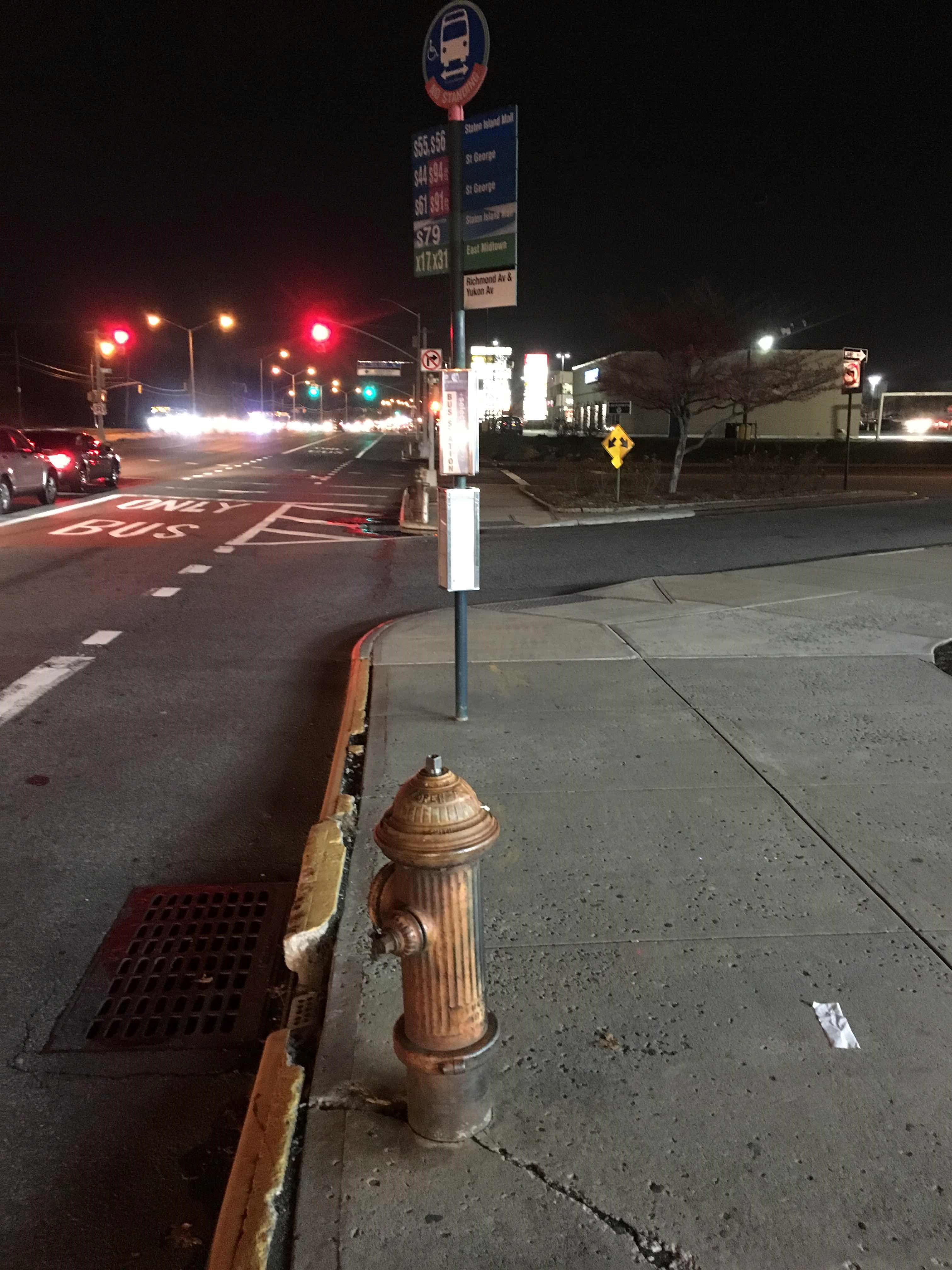 Taken by Zay L.
See Richmond Av/Yukon Av stop, Staten Island, on the map
Public transit to Richmond Av/Yukon Av stop in Staten Island
Looking for directions to Richmond Av/Yukon Av in Staten Island, United States?
Download the Moovit App to find the current schedule and step-by-step directions for Bus, Train or Subway routes that pass through Richmond Av/Yukon Av.
Looking for the nearest stops closest to Richmond Av/Yukon Av ? Check out this list of closest stops to your destination: Yukon Av/Richmond Av; Richmond Av/Yukon Av; Oakwood Heights; Marsh Av/Windham Loop.
Bus: S59, S61, S79-SBS, SIM1C, SIM4C, S44, S91, S94, S89, SIM4, SIM8, SIM31, S55, SIM4X.Subway: SIR.
We make riding on public transit to Richmond Av/Yukon Av easy, which is why over 1.5 million users, including users in Staten Island trust Moovit as the best app for public transit.
Use the app to navigate to popular places including to the airport, hospital, stadium, grocery store, mall, coffee shop, school, college, and university.
The first line to this stop is SIM8, at 6:02 AM, and the last line is S44 at 5:58 AM.
2865 Richmond Ave, Staten Island, New York, NY, USA
This stop serves MTA New York City Transit - Express routes and MTA Bus’s lines
Bus stops near Richmond Av/Yukon Av stop
Subway station near Richmond Av/Yukon Av station
Popular public transit stations in Staten Island
Get around Staten Island by public transit!
Traveling around Staten Island has never been so easy. See step by step directions as you travel to any attraction, street or major public transit station. View bus and train schedules, arrival times, service alerts and detailed routes on a map, so you know exactly how to get to anywhere in Staten Island.
When traveling to any destination around Staten Island use Moovit's Live Directions with Get Off Notifications to know exactly where and how far to walk, how long to wait for your line, and how many stops are left. Moovit will alert you when it's time to get off — no need to constantly re-check whether yours is the next stop.
Wondering how to use public transit in Staten Island or how to pay for public transit in Staten Island? Moovit public transit app can help you navigate your way with public transit easily, and at minimum cost. It includes public transit fees, ticket prices, and costs. Looking for a map of Staten Island public transit lines? Moovit public transit app shows all public transit maps in Staten Island with all Bus, Train, Subway, Light Rail, Ferry and Cable Car routes and stops on an interactive map.
New York - New Jersey has 6 transit type(s), including: Bus, Train, Subway, Light Rail, Ferry and Cable Car, operated by several transit agencies, including Metro-North Railroad, NJ Transit, PATH, NJ Transit Rail, NICE bus, Norwalk Transit District, Bee-Line Bus, LIRR, Staten Island Railway, MTA Subway, Roosevelt Island Operating Corporation, MTA Bus, HART, Suffolk County Transit and Seastreak