
Spadina Station station - Wednesday schedule
| Line | Direction | Time |
|---|---|---|
| 510B | Queens Quay Loop at Lower Spadina Ave | 5:00 AM |
| 310 | Spadina Station | 5:05 AM |
| 510B | Queens Quay Loop at Lower Spadina Ave | 5:09 AM |
| 310 | Front St West at Bay St East Side - Union Station | 5:16 AM |
| 510B | Queens Quay Loop at Lower Spadina Ave | 5:18 AM |
| 510B | Queens Quay Loop at Lower Spadina Ave | 5:27 AM |
| 310 | Spadina Station | 5:35 AM |
| 510B | Queens Quay Loop at Lower Spadina Ave | 5:36 AM |
| 510 | Spadina Station | 5:43 AM |
| 510B | Queens Quay Loop at Lower Spadina Ave | 5:45 AM |
| 510 | Spadina Station | 5:52 AM |
| 510B | Queens Quay Loop at Lower Spadina Ave | 5:54 AM |
| 510 | Spadina Station | 6:01 AM |
| 510B | Queens Quay Loop at Lower Spadina Ave | 6:03 AM |
| 310 | Spadina Station | 6:05 AM |
| 510 | Spadina Station | 6:10 AM |
| 510B | Queens Quay Loop at Lower Spadina Ave | 6:12 AM |
| 510 | Spadina Station | 6:19 AM |
| 510B | Queens Quay Loop at Lower Spadina Ave | 6:21 AM |
| 510 | Spadina Station | 6:28 AM |
| 510B | Queens Quay Loop at Lower Spadina Ave | 6:30 AM |
| 510 | Spadina Station | 6:37 AM |
| 510B | Queens Quay Loop at Lower Spadina Ave | 6:39 AM |
| 510 | Spadina Station | 6:46 AM |
| 510B | Queens Quay Loop at Lower Spadina Ave | 6:48 AM |
Directions to Spadina Station station (Toronto) with public transit
The following transit lines have routes that pass near Spadina Station
How to get to Spadina Station station by bus?
Click on the bus route to see step by step directions with maps, line arrival times and updated time schedules.
How to get to Spadina Station station by train?
Click on the train route to see step by step directions with maps, line arrival times and updated time schedules.
How to get to Spadina Station station by subway?
Click on the subway route to see step by step directions with maps, line arrival times and updated time schedules.
Bus stops near Spadina Station stop in Toronto
- Harbord St at Spadina Ave, 1 min walk,
- Spadina Rd at Lowther Ave, 4 min walk,
- Spadina Rd at Bloor St West, 4 min walk,
- Bloor St West at Spadina Ave, 6 min walk,
- St George Station, 9 min walk,
Subway stations near Spadina Station station in Toronto
- Spadina, 1 min walk,
Streetcar stations near Spadina Station station in Toronto
- Spadina Station, 2 min walk,
- Spadina Ave at Sussex Ave, 3 min walk,
Bus lines to Spadina Station station in Toronto
- 94A, Ossington Station,
- 127, Townsley Loop at Townsley St,
- 510B, Queens Quay Loop at Lower Spadina Ave,
- 300A, Pearson Airport Terminal 1 - Ground Level Column R4,
- 300B, Kennedy Station - Platform B,
- 300S, Kipling Station,
- 26, Jane Station,
What are the closest stations to Spadina Station?
The closest stations to Spadina Station are:
- Harbord St at Spadina Ave is 33 meters away, 1 min walk.
- Spadina is 62 meters away, 1 min walk.
- Spadina Station is 83 meters away, 2 min walk.
- Spadina Ave at Sussex Ave is 194 meters away, 3 min walk.
- Spadina Rd at Lowther Ave is 267 meters away, 4 min walk.
- Spadina Rd at Bloor St West is 276 meters away, 4 min walk.
- Bloor St West at Spadina Ave is 405 meters away, 6 min walk.
- St George Station is 678 meters away, 9 min walk.
Which bus lines stop near Spadina Station?
These bus lines stop near Spadina Station: 127, 13B, 26, 7.
Which train line stops near Spadina Station?
MI
Which subway lines stop near Spadina Station?
These subway lines stop near Spadina Station: 1, 2.
What’s the nearest Streetcar station to Spadina Station in Toronto?
The nearest Streetcar station to Spadina Station in Toronto is Spadina Station. It’s a 2 min walk away.
What’s the nearest subway station to Spadina Station in Toronto?
The nearest subway station to Spadina Station in Toronto is Spadina. It’s a 1 min walk away.
What’s the nearest bus stop to Spadina Station in Toronto?
The nearest bus stop to Spadina Station in Toronto is Harbord St at Spadina Ave. It’s a 1 min walk away.
What time is the first Streetcar to Spadina Station in Toronto?
The 310 is the first Streetcar that goes to Spadina Station in Toronto. It stops nearby at 3:00 AM.
What time is the last Streetcar to Spadina Station in Toronto?
The 310 is the last Streetcar that goes to Spadina Station in Toronto. It stops nearby at 3:05 AM.
What time is the first subway to Spadina Station in Toronto?
The 2 is the first subway that goes to Spadina Station in Toronto. It stops nearby at 5:58 AM.
What time is the last subway to Spadina Station in Toronto?
The 1 is the last subway that goes to Spadina Station in Toronto. It stops nearby at 2:01 AM.
What time is the first bus to Spadina Station in Toronto?
The 300A is the first bus that goes to Spadina Station in Toronto. It stops nearby at 3:01 AM.
What time is the last bus to Spadina Station in Toronto?
The 300A is the last bus that goes to Spadina Station in Toronto. It stops nearby at 3:31 AM.
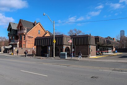
See Spadina Station station, Toronto, on the map
Public transit to Spadina Station station (ID: 15080) in Toronto
Looking for directions to Spadina Station in Toronto, Canada?
Download the Moovit App to find the current schedule and step-by-step directions for Bus, Subway or Train routes that pass through Spadina Station.
Looking for the nearest stops closest to Spadina Station ? Check out this list of closest stops to your destination: Harbord St at Spadina Ave; Spadina; Spadina Station; Spadina Ave at Sussex Ave; Spadina Rd at Lowther Ave; Spadina Rd at Bloor St West; Bloor St West at Spadina Ave; St George Station.
Bus: 127, 13B, 26, 7, 94A, 510B, 300A, 300B, 300S.Train: MI.Subway: 1, 2.
We make riding on public transit to Spadina Station easy, which is why over 1.5 million users, including users in Toronto trust Moovit as the best app for public transit.
Use the app to navigate to popular places including to the airport, hospital, stadium, grocery store, mall, coffee shop, school, college, and university.
Spadina Station station’s code is 15080
The first line to this station is 510B, at 5:00 AM, and the last line is 310 at 4:46 AM.
7 Spadina Rd, Toronto, ON, Canada
This station serves TTC Streetcar and TTC’s lines
Bus stops near Spadina Station stop
Subway station near Spadina Station station
Popular public transit stations in Toronto
Get around Toronto by public transit!
Traveling around Toronto has never been so easy. See step by step directions as you travel to any attraction, street or major public transit station. View bus and train schedules, arrival times, service alerts and detailed routes on a map, so you know exactly how to get to anywhere in Toronto.
When traveling to any destination around Toronto use Moovit's Live Directions with Get Off Notifications to know exactly where and how far to walk, how long to wait for your line, and how many stops are left. Moovit will alert you when it's time to get off — no need to constantly re-check whether yours is the next stop.
Wondering how to use public transit in Toronto or how to pay for public transit in Toronto? Moovit public transit app can help you navigate your way with public transit easily, and at minimum cost. It includes public transit fees, ticket prices, and costs. Looking for a map of Toronto public transit lines? Moovit public transit app shows all public transit maps in Toronto with all Bus, Train, Subway, Streetcar and Ferry routes and stops on an interactive map.
Toronto has 5 transit type(s), including: Bus, Train, Subway, Streetcar and Ferry, operated by several transit agencies, including TTC, TTC Streetcar, Toronto Subway, GO Transit Bus, GO Transit, Hamilton Street Railway, Grand River Transit, MiWay, Burlington Transit, Guelph Transit, Oakville Transit, Brampton Transit, York Region Transit, UP Express and Barrie Transit