The Most Popular Urban Mobility App in Dublin.
All local mobility options in one app
| Line | Direction | Time |
|---|---|---|
| 783 | Dublin Airport T1 | 3:39 AM |
| 783 | Dublin Airport T1 | 4:39 AM |
| 783 | Dublin Airport T1 | 5:09 AM |
| 783 | Dublin Airport T1 | 5:39 AM |
| 783 | Dublin Airport T1 | 6:09 AM |
| 783 | Dublin Airport T1 | 6:39 AM |
| 783 | Dublin Airport T1 | 7:09 AM |
| 783 | Dublin Airport T1 | 7:39 AM |
| 783 | Dublin Airport T1 | 8:09 AM |
| 783 | Dublin Airport T1 | 8:39 AM |
| 783 | Dublin Airport T1 | 9:09 AM |
| 783 | Dublin Airport T1 | 9:39 AM |
| 783 | Dublin Airport T1 | 10:09 AM |
| 783 | Dublin Airport T1 | 10:39 AM |
| 783 | Dublin Airport T1 | 11:09 AM |
| 783 | Dublin Airport T1 | 11:39 AM |
| 783 | Dublin Airport T1 | 12:09 PM |
| 783 | Dublin Airport T1 | 12:39 PM |
| 783 | Dublin Airport T1 | 1:09 PM |
| 783 | Dublin Airport T1 | 1:39 PM |
| 783 | Dublin Airport T1 | 2:09 PM |
| 783 | Dublin Airport T1 | 2:39 PM |
| 783 | Dublin Airport T1 | 3:09 PM |
| 783 | Dublin Airport T1 | 3:39 PM |
| 783 | Dublin Airport T1 | 4:09 PM |
The following transit lines have routes that pass near Winetavern Street
Click on the Bus route to see step by step directions with maps, line arrival times and updated time schedules.
Click on the Train route to see step by step directions with maps, line arrival times and updated time schedules.
The closest stations to Winetavern Street are:
These Bus lines stop near Winetavern Street: 123, 26, 27, 39, 54A, 70, 74, 783
These Train lines stop near Winetavern Street: DART, RAIL
The nearest light rail station to Winetavern Street in Dublin is Jervis. It’s a 3 min walk away.
The nearest bus stop to Winetavern Street in Dublin is High Street. It’s a 2 min walk away.
The RED is the first Light Rail that goes to Winetavern Street in Dublin. It stops nearby at 7:12 AM.
The RED is the last Light Rail that goes to Winetavern Street in Dublin. It stops nearby at 11:45 PM.
The C2 is the first Bus that goes to Winetavern Street in Dublin. It stops nearby at 3:00 AM.
The C5 is the last Bus that goes to Winetavern Street in Dublin. It stops nearby at 3:20 AM.
The Bus fare to Winetavern Street costs about €1.30 - €2.00.
The Train fare to Winetavern Street costs about €1.30 - €2.00.
The Light Rail fare to Winetavern Street costs about €1.30 - €2.00.
Looking for directions to Winetavern Street in Dublin, Ireland?
Download the Moovit App to find the current schedule and step-by-step directions for Bus, Train or Light Rail routes that pass through Winetavern Street.
Looking for the nearest stops closest to Winetavern Street ? Check out this list of closest stops to your destination: High Street; Jervis; Lord Edward Street; Dublin City South; Winetavern Street; Patrick Street; Four Courts; Merchant's Quay.
Bus:Train:
We make riding on public transit to Winetavern Street easy, which is why over 1.5 million users, including users in Dublin trust Moovit as the best app for public transit.
Use the app to navigate to popular places including to the airport, hospital, stadium, grocery store, mall, coffee shop, school, college, and university.
The first line to this stop is 783, at 3:39 AM, and the last line is 783 at 11:09 PM.
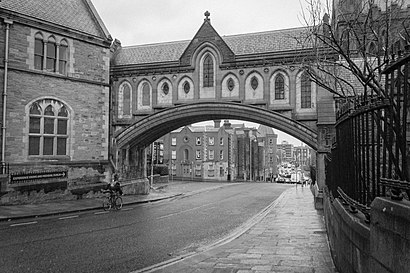
St Michael's Hill, Dublin, Ireland
This stop serves Bernard Kavanagh & Sons’s lines
Winetavern Street (Irish: Sráid an Fhíona) is a street in the medieval area of Dublin, Ireland.Wiki