Line network Dresden Offline Map (PDF)
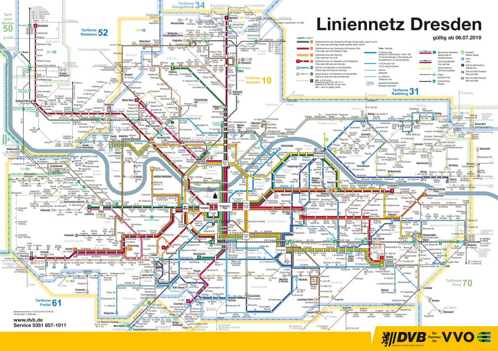
Moovit has an easy-to-download Line network Dresden map, that serves as your offline Dresden ferry, bus, train, light rail or gondola map while traveling. This map can be saved in your phone and it’s easy to share with friends. To view the downloaded map, no internet connection is required. It’s the offline ferry, bus, train, light rail or gondola map in Dresden that will take you where you need to go.
Moovit has an easy-to-download Line network Dresden map, that serves as your offline Dresden ferry, bus, train, light rail or gondola map while traveling. This map can be saved in your phone and it’s easy to share with friends. To view the downloaded map, no internet connection is required. It’s the offline ferry, bus, train, light rail or gondola map in Dresden that will take you where you need to go.
Find all ferry line schedules and routes in Dresden:
- Bad Schandau
 S1
S1 - Ockerwitz - Waltherstraße92
- Altleuben65 (ALITA)
- Südvorstadt - Hellerau8
- Striesen - Löbtau-Süd85
- Boxdorf72
- Pillnitz - Bonnewitz83
- Bad SchandauU28
- Pieschen - Wilder Mann73
- Loschwitz - OberloschwitzSCHWEBEBAHN
- Weißig - Niederpoyritz98A
- Gorbitz - Kleinzschachwitz2
- Betriebshof Gruna61
- Justizvollzugsanstalt76
- Waldschlößchen - Jägerpark74 (ALITA)
- Mickten79
- Freital / Mockritz - Lockwitz / Nickern66
- Karcherallee63
- Münzteichweg - Wasaplatz / Zschertnitz63 (ALITA)
- Bühlau - Rossendorf229
- Dresden - TharandtS3
- Pirna - Dresden-FlughafenS2
- DippoldiswaldeWTB
- Liststraße - Wilschdorf81 (ALITA)
- Graupa83 (ALITA)
- Omsewitz - Bahnhof Klotzsche80
- Marienallee - Jägerpark, Heideblick74
- Messe Dresden10
- Cotta - Ockerwitz92 (ALITA)
- Blasewitz - Rochwitz84 (ALITA)
- Prohlis - Lockwitz66 (ALITA)
- Flughafen - Klotzsche, Infineon Nord77 (ALITA)
- Bahnhof Neustadt - Wilschdorf81
- Altenberger Straße87
- Dresden - HoyerswerdaRE15
- Niedersedlitz - Röhrsdorf89
- Hellerau - Infineon Nord8 (ALITA)
- Weixdorf - Pennrich7
- Pirna Stadtmitte - DohmaZ
- Am Altfrankener Park - Dahlienweg / Wilschdorf - Bahnhof Klotzsche70 (ALITA)
- Leutewitz - Zschonergrund97 (ALITA)
- Klotzsche, Infineon – Flughafen – Klotzsche, Industriegebiet Nord – / Weixdorf – Marsdorf, Zum Spitzeberg77
- LößnitzgrundbahnLGB
- Bahnhof Klotzsche70
- Wilder Mann - Coschütz3
- Justizvollzugsanstalt76 (ALITA)
- Mickten79 (ALITA)
- Schönfeld - Borsberg98C
- Goppeln - Kleinzschachwitz, Fähre88
- Kreischa - Heidenau86
- Weißig - Niederpoyritz98B
- Cotta91 (ALITA)
- Blasewitz - Bühlau84
- Anton-/Leipziger Straße11
- Prohlis - Kleinzschachwitz Fähre88 (ALITA)
- Striesen - Leutewitz12
- Kaditz - Reick64
- Coschütz / Südhöhe - Freital / Bannewitzer Straße66 (ALITA)
- Dresden - ChemnitzRB30
- Gohlis - Cossebaude95 (ALITA)
- Niedersedlitz - Wölfnitz6
- Laubegast4
- Oberwartha - Cotta93
- Cotta91
- GraupaP
- Pieschen - Wilder Mann73 (ALITA)
- Prohlis - Leutewitz1
- Prohlis - Kaditz9
- ElbePark - Serkowitz / Hellerau - Boxdorf72 (ALITA)
- Kaditz13
- Niedersedlitz - Lockwitz / Röhrsdorf89 (ALITA)
- Blasewitz - Heidenau / Luga65
- Johannstadt - Dölzschen62