How to get to Radioshack by bus?
Click on the bus route to see step by step directions with maps, line arrival times and updated time schedules.
From Hotel Aka Back Bay (Hotel Back Bay), Boston
59 minFrom Boch Center, Boston
42 minFrom Fire & Ice (Fire Ice Restaurant), Boston
60 minFrom The Middle East Restaurant, Cambridge
71 minFrom Takeda Pharmaceuticals, Cambridge
81 minFrom Fire + Ice, Boston
60 minFrom Charles/MGH T Stop, Boston
39 minFrom Trinity Church, Boston
48 minFrom Cambria Hotel Boston Somerville, Somerville
63 minFrom Citrus & Salt, Boston
59 min
How to get to Radioshack by subway?
Click on the subway route to see step by step directions with maps, line arrival times and updated time schedules.
From Hotel Aka Back Bay (Hotel Back Bay), Boston
72 minFrom Boch Center, Boston
69 minFrom Fire & Ice (Fire Ice Restaurant), Boston
74 minFrom The Middle East Restaurant, Cambridge
81 minFrom Takeda Pharmaceuticals, Cambridge
84 minFrom Fire + Ice, Boston
74 minFrom Charles/MGH T Stop, Boston
73 minFrom Trinity Church, Boston
76 minFrom Cambria Hotel Boston Somerville, Somerville
98 minFrom Citrus & Salt, Boston
72 min
Bus stops near Radioshack in Revere
Subway station near Radioshack in Revere
- Revere Beach, 36 min walk,VIEW
Bus lines to Radioshack in Revere
What are the closest stations to Radioshack?
The closest stations to Radioshack are:
- Squire Rd @ Super Stop + Shop is 509 yards away, 7 min walk.
- Wesley St @ Lynn St - Linden Sq is 991 yards away, 13 min walk.
- Revere Beach is 3030 yards away, 36 min walk.
Which bus lines stop near Radioshack?
These bus lines stop near Radioshack: 109, 426.
Which subway line stops near Radioshack?
BLUE LINE (Wonderland)
What’s the nearest bus station to Radioshack in Revere?
The nearest bus station to Radioshack in Revere is Squire Rd @ Super Stop + Shop. It’s a 7 min walk away.
What time is the first subway to Radioshack in Revere?
The BLUE LINE is the first subway that goes to Radioshack in Revere. It stops nearby at 5:12 AM.
What time is the last subway to Radioshack in Revere?
The BLUE LINE is the last subway that goes to Radioshack in Revere. It stops nearby at 2:10 AM.
What time is the first bus to Radioshack in Revere?
The 119 is the first bus that goes to Radioshack in Revere. It stops nearby at 5:00 AM.
What time is the last bus to Radioshack in Revere?
The 109 is the last bus that goes to Radioshack in Revere. It stops nearby at 1:45 AM.
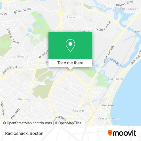
See Radioshack, Revere, on the map
Public Transit to Radioshack in Revere
Wondering how to get to Radioshack in Revere? Moovit helps you find the best way to get to Radioshack with step-by-step directions from the nearest public transit station.
Moovit provides free maps and live directions to help you navigate through your city. View schedules, routes, timetables, and find out how long does it take to get to Radioshack in real time.
Looking for the nearest stop or station to Radioshack? Check out this list of stops closest to your destination: Squire Rd @ Super Stop + Shop; Wesley St @ Lynn St - Linden Sq; Revere Beach.
Bus: 109, 426, 119, 411, 428, 429.Subway: BLUE LINE.
Want to see if there’s another route that gets you there at an earlier time? Moovit helps you find alternative routes or times. Get directions from and directions to Radioshack easily from the Moovit App or Website.
We make riding to Radioshack easy, which is why over 1.7 million users, including users in Revere, trust Moovit as the best app for public transit. You don’t need to download an individual bus app or train app, Moovit is your all-in-one transit app that helps you find the best bus time or train time available.
For information on prices of bus and subway, costs and ride fares to Radioshack, please check the Moovit app.
Use the app to navigate to popular places including to the airport, hospital, stadium, grocery store, mall, coffee shop, school, college, and university.
Radioshack Address: 339 Squire Rd street in Revere
- Copeland Circle / Cutler Circle,
- Route 60/Rt. 1 N/S Rotary,
- Four Points by Sheraton Boston Logan Airport,
- Four Points by Sheraton,
- The Layover Bar Lobby Bar Sheraton Revere,
- Restoration Christian Church,
- Bisuteki Steak House & Sushi Bar,
- The Landing Cafe,
- Darsa Tv,
- Wow Bao,
- La Serena Studios,
- Imagination Station Early Learning Center,
- Mikeadv,
- Aguirre Modern Tile Masonry, Llc,
- Doughboy Uniforms,
- Bank Of America Financial Center & Walk-Up Atm | Revere - Squire Rd,
- Coinme,
- Strength Discovery,
- Chase Bank,
- Stop & Shop
Places Near Radioshack (Revere)
- Castle Island, Boston,
- Boston Common, Boston,
- Quincy Market, Boston,
- Seaport District, Boston,
- Massachusetts General Hospital, Boston,
- House Of Blues, Boston,
- Leader Bank Pavilion (Leader Bank Pavillion), Boston,
- Faneuil Hall, Boston,
- Museum Of Science, Boston,
- Boston Children's Hospital, Boston,
- Mgm Music Hall, Boston,
- Wang Theater, Boston,
- Boston Medical Center, Boston,
- Boston Convention & Exhibition Center, Boston,
- Isabella Stewart Gardner Museum, Boston,
- Td Garden, Boston,
- Prudential Center, Boston,
- Wilbur Theatre, Boston,
- North End, Boston,
- Cheers, Boston
How to get to popular places in Boston with public transit
Get around Revere by public transit!
Traveling around Revere has never been so easy. See step by step directions as you travel to any attraction, street or major public transit station. View bus and train schedules, arrival times, service alerts and detailed routes on a map, so you know exactly how to get to anywhere in Revere.
When traveling to any destination around Revere use Moovit's Live Directions with Get Off Notifications to know exactly where and how far to walk, how long to wait for your line, and how many stops are left. Moovit will alert you when it's time to get off — no need to constantly re-check whether yours is the next stop.
Wondering how to use public transit in Revere or how to pay for public transit in Revere? Moovit public transit app can help you navigate your way with public transit easily, and at minimum cost. It includes public transit fees, ticket prices, and costs. Looking for a map of Revere public transit lines? Moovit public transit app shows all public transit maps in Revere with all Bus, Train, Subway and Ferry routes and stops on an interactive map.
Boston has 4 transit type(s), including: Bus, Train, Subway and Ferry, operated by several transit agencies, including MBTA, Southeastern Regional Transit Authority, MetroWest Regional Transit Authority, Rhode Island Public Transit Authority, WRTA, Lowell Regional Transit Authority, Merrimack Valley Transit, Montachusett Regional Transit Authority, Cape Cod Regional Transit Authority, Brockton Area Transit Authority, Martha's Vineyard Transit Authority, the WAVE - Nantucket Regional Transit Authority, GATRA, Cape Ann Transportation Authority and Massport
Public transit lines with stations closest to Radioshack in Revere
Subway lines with stations closest to Radioshack in Revere
Bus lines with stations closest to Radioshack in Revere
Squire Rd @ Super Stop + Shop
 119Beachmont via Tomasello Way - Northgate via Tomasello Way
- 411Malden - Jack Satter House
- 426Haymarket via Cliftondale - Central Square via Cliftondale
- 428Haymarket via Cliftondale (Express) - Oaklandvale via Cliftondale (Express)
- 429Central Square via Square One Mall - Northgate Shopping Center via Square One Mall