20 Line
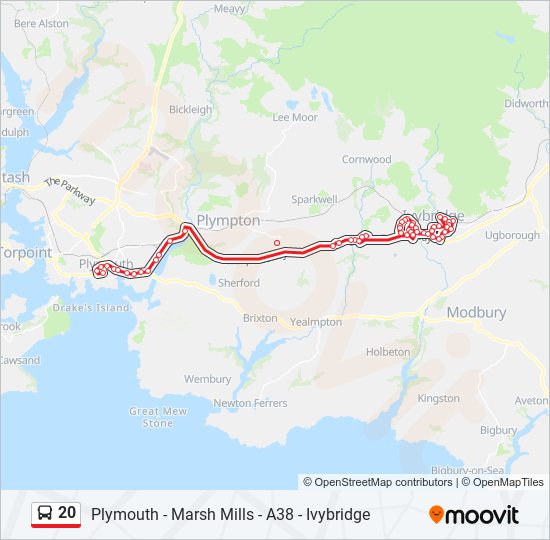
Plymouth - Marsh Mills - A38 - Ivybridge
Plymouth Citybus
Plymouth Citybus 20 Bus Route Schedule and Stops (Updated)
The 20 bus (Plymouth City Centre) has 54 stops departing from Town Hall, Ivybridge and ending at Royal Parade A10, Plymouth City Centre (A10).
Choose any of the 20 bus stops below to find updated real-time schedules and to see their route map.
Direction: Plymouth City Centre (54 stops)
Town Hall, Ivybridge
Sportsmans Inn, Ivybridge
Marshalls Field, Ivybridge
Rue St Pierre, Ivybridge
Macandrew Walk, Ivybridge
Prideaux Road, Ivybridge
Jubilee Close, Ivybridge
Speakers Road, Ivybridge
Railway Station, Ivybridge
Torre Close, Ivybridge
Waterslade Drive, Ivybridge
Filham Moor Close, Ivybridge
Waltham Way, Ivybridge
Widdicombe Drive, Ivybridge
Bp Garage, Ivybridge
South Dartmoor Leisure Centre, Ivybridge
Clare Street, Ivybridge
Westover Close, Ivybridge
Ivydene Road, Ivybridge
Cemetery, Ivybridge
Allotment Gardens, Ivybridge
Priory Close, Ivybridge
Fairway Avenue, Ivybridge
Langham Levels, Ivybridge
Mallet Road, Ivybridge
Abbot Road, Ivybridge
Summerfield Court, Ivybridge
Holtwood Drive, Ivybridge
Woolms Meadow, Ivybridge
Cameron Drive, Ivybridge
Westover Lane, Ivybridge
Lee Mill
Tesco Superstore, Lee Mill
Tesco, Lee Mill
Westward Inn, Lee Mill
New Park Road, Lee Mill
Holmleigh, Smithaleigh
New Country Inn, Smithaleigh
Sandy Road West, Chaddlewood
Sandy Road East, Chaddlewood
Marsh Mills Superstore, Crabtree
Laira Flyover, Laira
Rowing Club, Laira
Lanhydrock Road, Mount Gould
Hele's Terrace, Prince Rock
Elliott Road, Prince Rock
Astor Fields, Cattedown
St Johns Church, Cattedown
Charles Church, Plymouth City Centre
Charles Street C2, Plymouth City Centre
Mayflower Street M1, Plymouth City Centre
Western Approach Flats, Plymouth City Centre
Western Approach, Plymouth City Centre
Royal Parade A10, Plymouth City Centre (A10)
20 FAQ
What time does the 20 bus start operating?
Services on the 20 bus start at 06:45 on Monday, Tuesday, Wednesday, Thursday, Friday, Saturday.
What time does the 20 bus stop working?
Services on the 20 bus stop at 18:55 on Monday, Tuesday, Wednesday, Thursday, Friday, Saturday.
What time does the 20 bus arrive?
When does the Plymouth - Marsh Mills - A38 - Ivybridge bus line come? Check Live Arrival Times for live arrival times and to see the full schedule for the Plymouth - Marsh Mills - A38 - Ivybridge bus line that is closest to your location.
Is there a 20 bus stop near me?
Click here to view the nearest 20 bus stop.
Plymouth Citybus Service Alerts
See all updates on 20 (from Town Hall, Ivybridge), including real-time status info, bus delays, changes of routes, changes of stops locations, and any other service changes. Get a real-time map view of 20 (Plymouth City Centre) and track the bus as it moves on the map. Download the app for all Plymouth Citybus info now.
20 line bus fare
Plymouth Citybus 20 (Plymouth City Centre) prices may change based on several factors. For more information about Plymouth Citybus tickets costs please check the Moovit app or Plymouth Citybus’s official website.

20 (Plymouth Citybus)
The first stop of the 20 bus route is Town Hall, Ivybridge and the last stop is Royal Parade A10, Plymouth City Centre (A10). 20 (Plymouth City Centre) is operational during weekdays.
Additional information: 20 has 54 stops and the total trip duration for this route is approximately 68 minutes.
On the go? See why over 1.5 million users trust Moovit as the best public transport app. Moovit gives you Plymouth Citybus suggested routes, real-time bus tracker, live directions, line route maps in South West, and helps to find the closest 20 bus stops near you. No internet available? Download an offline PDF map and bus schedule for the 20 bus to take on your trip.
Line 20 Real Time bus Tracker
Track line 20 (Plymouth City Centre) on a live map in real time and follow its location as it moves between stations. Use Moovit as a line 20 bus tracker or a live Plymouth Citybus bus tracker app and never miss your bus.
Use the app as a trip planner for Plymouth Citybus or a trip planner for bus, ferry or train to plan your route around South West. The trip planner shows updated data for Plymouth Citybus and any bus, including line 20, in South West
20 - Alternative Directions
Plymouth Citybus Lines in South West
- 44 - Plymouth City Centre - Mutley - Whitleigh/ Timetable
- 105 - DHS Boys - Yelverton - Tavistock/ Timetable
- 28 - Plymouth City Centre - Deer Pk - Eggbuckland - Derriford Hosp - The George P&R/ Timetable
- 104 - DHS Boys - Roborough/ Timetable
- 808 - Peverell- Coombe Dean/ Timetable
- 5A - Plymouth City Cente - Plymstock - Elburton/ Timetable
- 55 - Tavistock - Yelverton - Milton Coombe/ Timetable
- 35 - Plymouth City Centre - Ham - Plymouth City Centre/ Timetable
- 23 - Plymouth City Centre - Greenbank - Mount Gould - Plymouth City Centre/ Timetable
- 42C - Plymouth City Centre - Derriford Hospital - Woolwell/ Timetable
- 24 - Plymouth City Centre - Mount Gould - Greenbank - Plymouth City Centre/ Timetable
- 27 - Plymouth City Centre - Eggbuckland - Estover Asda - Derriford Hospital/ Timetable
- 21 - Barne Barton - Devonport - Plymouth City Centre - Plympton/ Timetable
- 61 - Plymouth City Centre - Honicknowle - Transit Way/ Timetable
- 26 - St Austell - Bodmin/ Timetable
- 25 - Plymouth City Centre - Barbican -The Hoe - Plymouth City Centre/ Timetable
- 36 - Plymouth City Centre - City College - Devonport/ Timetable
- 56 - Tavistock - Walkhampton - Tavistock/ Timetable
- 34 - Plymouth City Centre - Devonport - Milehouse - Derriford Hospital - Estover Ind Est - The George P&R/ Timetable
- 33 - Plymouth City Centre - Keyham - Plymouth City Centre/ Timetable
